Pictures of the Week 2008-17
Hello All,
After a fun week in Alamogordo it was time to move on down the road. We jumped on Highway 54 north to Carrizozo and then turned west on Highway 380. We made a quick stop at the Valley of Fire National Recreation Area and then continued west until intercepting I-25. We followed I-25 north to Albuquerque where we dropped anchor again.
We spent a day exploring the sites around Albuquerque. Our first stop was “Old Town.” While it was unique with a lot of history and neat architecture, however, we found it quite commercialized with a lot of high end shops. Probably one of the most interesting things we came across was a group of old Navajo “Code Talkers” doing a book signing. These guys were a valuable asset during World War II. Since the Navajo language was unwritten they were used to pass radio messages to allied forces during the war. Consequently the Germans were unable to decipher the radio transmissions.
Albuquerque International Balloon Museum was our next venture. It was interesting and informative. However, it just whet our appetite to see the International Balloon Fiesta that takes place for nine days every October. Albuquerque’s Balloon Fiesta is an amazingly diverse event that brings together huge numbers of balloons and pilots from all over the world. Mass ascensions fill the sky with balloons as far as you can see. The fiesta is high on our “Bucket List.”
Our next stop was the Sandia Peak Tramway. It’s a short trip from the heart of Albuquerque to the world’s longest aerial tramway. The tram travels for 2.7 miles to the top of 10,378 Sandia Peak. Since the weather at the top of the mountain was 34 degrees with a 10 mph wind we decided not to ride the tram to the top. Instead we hopped into the truck and drove to the top where snow was on the ground. Snapped a few photos and then climbed back into the warm truck and called it a day.
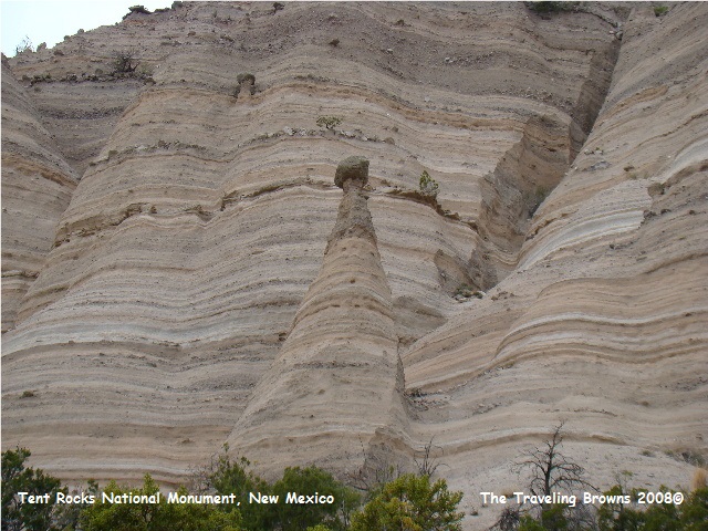
We were off and running early the next morning. Our first stop was at Kasha-Katuwe Tent Rocks National Monument located West of Santa Fe, NM. What an awesome awesome place! We were simply blown away with the spectacular scenery--we had never seen anything like it before. The cone-shaped tent rock formations are the products of volcanic eruptions that occurred 6 to 7 million years ago and left pumice, ash and tuff deposits over 1,000 feet thick. Tremendous explosions from the Jemez volcanic field spewed pyroclasts (rock fragments), while searing hot gases blasted down slopes in an incandescent avalanche called a “pyroclastic flow.” Small rounded translucent obsidian (volcanic glass) fragments were created by rapid cooling. We were instructed not to remove any of the volcanic beads.
After a fun week in Alamogordo it was time to move on down the road. We jumped on Highway 54 north to Carrizozo and then turned west on Highway 380. We made a quick stop at the Valley of Fire National Recreation Area and then continued west until intercepting I-25. We followed I-25 north to Albuquerque where we dropped anchor again.
We spent a day exploring the sites around Albuquerque. Our first stop was “Old Town.” While it was unique with a lot of history and neat architecture, however, we found it quite commercialized with a lot of high end shops. Probably one of the most interesting things we came across was a group of old Navajo “Code Talkers” doing a book signing. These guys were a valuable asset during World War II. Since the Navajo language was unwritten they were used to pass radio messages to allied forces during the war. Consequently the Germans were unable to decipher the radio transmissions.
Albuquerque International Balloon Museum was our next venture. It was interesting and informative. However, it just whet our appetite to see the International Balloon Fiesta that takes place for nine days every October. Albuquerque’s Balloon Fiesta is an amazingly diverse event that brings together huge numbers of balloons and pilots from all over the world. Mass ascensions fill the sky with balloons as far as you can see. The fiesta is high on our “Bucket List.”
Our next stop was the Sandia Peak Tramway. It’s a short trip from the heart of Albuquerque to the world’s longest aerial tramway. The tram travels for 2.7 miles to the top of 10,378 Sandia Peak. Since the weather at the top of the mountain was 34 degrees with a 10 mph wind we decided not to ride the tram to the top. Instead we hopped into the truck and drove to the top where snow was on the ground. Snapped a few photos and then climbed back into the warm truck and called it a day.
We were off and running early the next morning. Our first stop was at Kasha-Katuwe Tent Rocks National Monument located West of Santa Fe, NM. What an awesome awesome place! We were simply blown away with the spectacular scenery--we had never seen anything like it before. The cone-shaped tent rock formations are the products of volcanic eruptions that occurred 6 to 7 million years ago and left pumice, ash and tuff deposits over 1,000 feet thick. Tremendous explosions from the Jemez volcanic field spewed pyroclasts (rock fragments), while searing hot gases blasted down slopes in an incandescent avalanche called a “pyroclastic flow.” Small rounded translucent obsidian (volcanic glass) fragments were created by rapid cooling. We were instructed not to remove any of the volcanic beads.
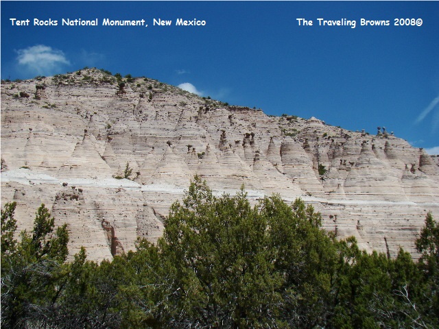
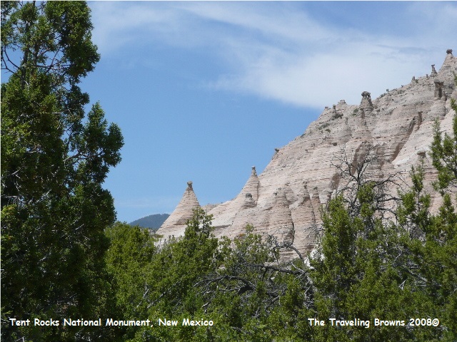
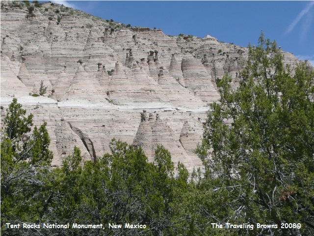
Precariously perched on many
of the tapering hoodoos are boulder caps that protect the softer pumice and
tuff below. Some tents have lost their
hard, resistant caprocks and are disintegrating. While fairly uniform in shape, the tent rock
formations vary in height from a few feet to 90 feet.
After a fantastic morning
hiking the trails through the tent rocks we jumped into the truck and proceeded
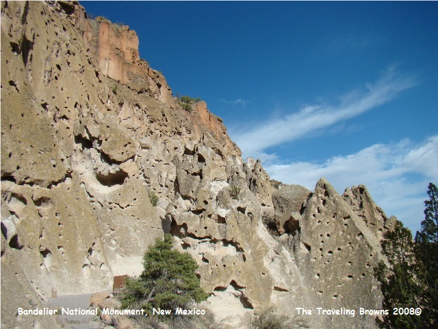
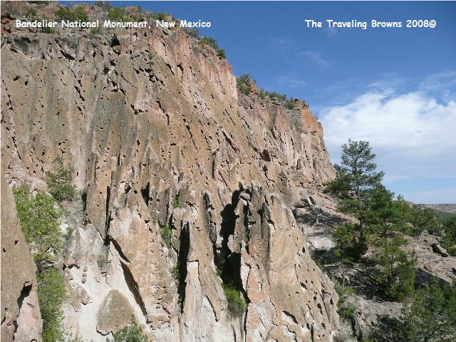
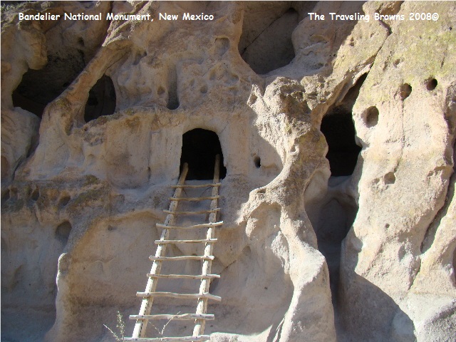
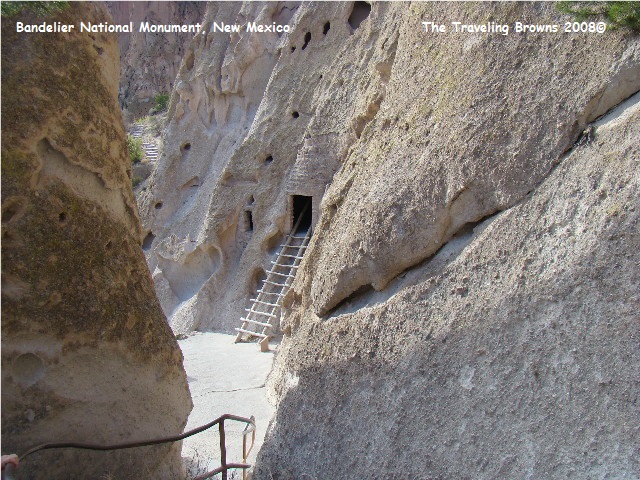
to Bandelier National Monument in Frijoles Canyon South of Los Alamos, NM. The canyon and mesa country around Bandelier
is part of the Pajarito Plateau. It was
formed by two violent eruptions of the Jemez (pronounced Hay-mess) Volcano more
that one million years ago. Located fourteen miles to the northwest, this
powerful volcano ejected enough material to cover this four-hundred square mile
area with a layer of volcanic ash up to one thousand feet thick. Each of the two Jemez eruptions was six
hundred times more powerful than the 1980 eruption of Mount St. Helens.
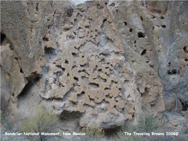
The pink rock of the canyon wall may look like sandstone, but it is actually volcanic ash that compacted over time into a soft, crumbly rock called tuff. Tuff is very easily eroded by the action of wind and rain. Some components of the tuff erode more easily than others. Over time the exposed rock takes on a “Swiss cheese” appearance.
The pink rock of the canyon wall may look like sandstone, but it is actually volcanic ash that compacted over time into a soft, crumbly rock called tuff. Tuff is very easily eroded by the action of wind and rain. Some components of the tuff erode more easily than others. Over time the exposed rock takes on a “Swiss cheese” appearance.
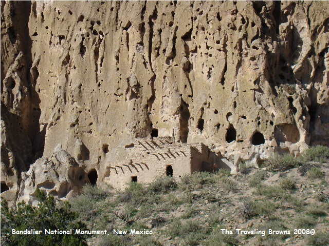
Frijoles Creek is one of the
few places on the Plateau where water flows year-round. It being a reliable source of water must have
been a very important reason why to the Ancestral Pueblo people settled in the
canyon. We spent the afternoon hiking
the trails through the ruins of the Pueblos and cliff dwellings. Human activity in the area dates back more
than 10,000 years.
We had planned on taking a day
off to rest after our visit to Tent Rocks & Bandelier National Monument but
the weather forecast changed that. A
cold front was to move through the area in two days bringing wind in excess of
50 mph. So we headed out the next
morning for El Malpais National Monument south of Grants, NM.
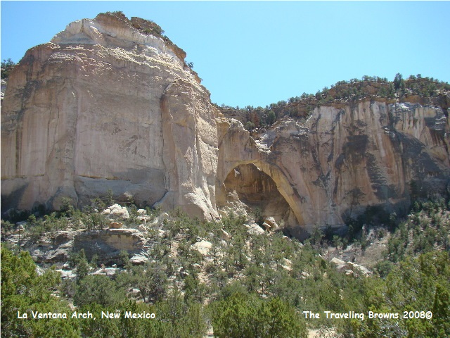
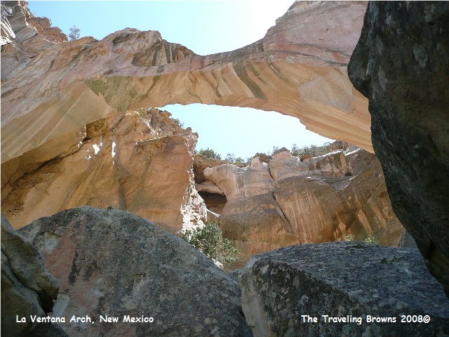
Our first stop within the monument was La Ventana Natural Arch. It is the largest of New Mexico’s natural arches and was eroded from sandstone dating back to the age of dinosaurs. We were disappointed in the view of the arch from the end of the park service trail. So Barb and I started climbing in, around, and over huge boulders to try and get a better vantage point. We took our time and helped each other all the way. The only worrisome thing was watching out for rattlesnakes. After one and a half hours of climbing we finally reached a point where we could get descent photos--it was awesome!! And yes, we made it down safely with only a few scratches, tired legs, and sore muscles.
Our first stop within the monument was La Ventana Natural Arch. It is the largest of New Mexico’s natural arches and was eroded from sandstone dating back to the age of dinosaurs. We were disappointed in the view of the arch from the end of the park service trail. So Barb and I started climbing in, around, and over huge boulders to try and get a better vantage point. We took our time and helped each other all the way. The only worrisome thing was watching out for rattlesnakes. After one and a half hours of climbing we finally reached a point where we could get descent photos--it was awesome!! And yes, we made it down safely with only a few scratches, tired legs, and sore muscles.
By the time we got back to the
truck the wind was blowing strong--it arrived earlier than scheduled!! Our next stop in the monument was at the
Sandstone Bluffs Overlook. This ridge
offers an excellent vista of the El Malpais lava flows and surrounding
countryside. We snapped a couple of
photos but the wind was lifting sand and literally sand blasted us off the
bluffs. On the drive back into Grants
visibility dropped to zero in one area--it was a bit spooky.
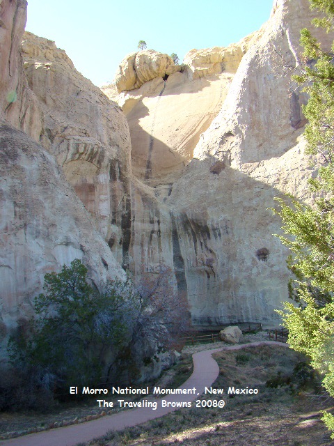
We stopped at the El Malpais visitor center. The ranger suggested we visit the El Morro National Monument & Inscription Rock southwest of Grants. She stated that with how El Morro lies it should block the wind--so off we went.
El Morro is a cuesta--a long formation with a gentle upward slope that drops off abruptly at one end. When snow melts and thunderstorms dump their rain, water flushes off of El Morro’s cap rock. Over time these waters carved channels through the upper rock, and shaped plunge-points where water dropped into a pool at the base.
We stopped at the El Malpais visitor center. The ranger suggested we visit the El Morro National Monument & Inscription Rock southwest of Grants. She stated that with how El Morro lies it should block the wind--so off we went.
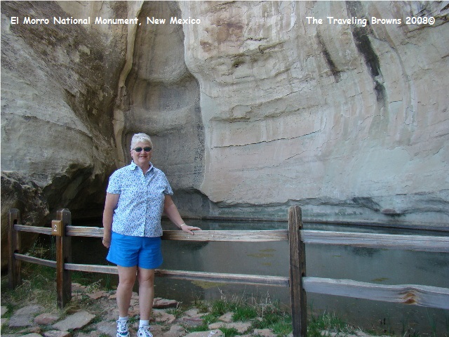
El Morro is a cuesta--a long formation with a gentle upward slope that drops off abruptly at one end. When snow melts and thunderstorms dump their rain, water flushes off of El Morro’s cap rock. Over time these waters carved channels through the upper rock, and shaped plunge-points where water dropped into a pool at the base.
The pool, fresh and clear after storms, was a
rare treasure in the high desert. The
pool is about twelve feet deep and holds approximately 200,000 gallons of
water.
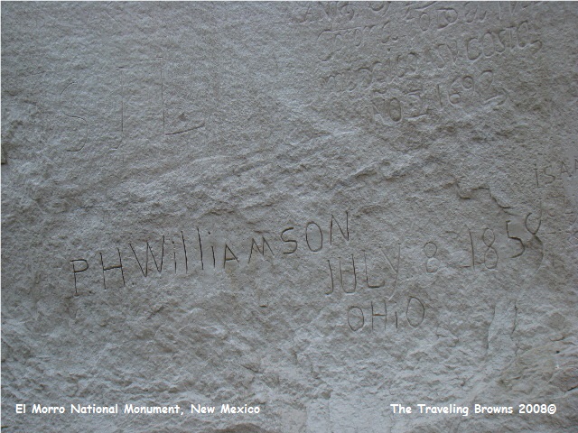
Travelers along the ancient
trade route depended on El Morro’s source of water. First were the Puebloans (ancient villagers
about 2,000 years ago), then the New World Colonizers (primarily the Spaniards
in the 1500-1800’s), and then the
Americans expanding westward in the mid 1800’s. Drawn to this water many
travelers recorded their passage on the rock--hence the name “Inscription Rock.”
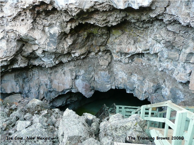
On the return trip to
Albuquerque we passed The Land of Fire & Ice so we decided to stop and
check it out. Their claim to fame is you
can climb a volcano or chill out in an ice cave. It is situated on the Continental Divide
among Ponderosa Pines at an elevation of almost 8,000 feet. The area is called “the most moon-like
expanse of country on earth.” We hiked
along an ancient lava trail that led us to a collapsed lava tube. Then climbed down rickety old stairs that led
into the cave where there was an ice pool.
The temperature in the cave never rises above 31 degrees.
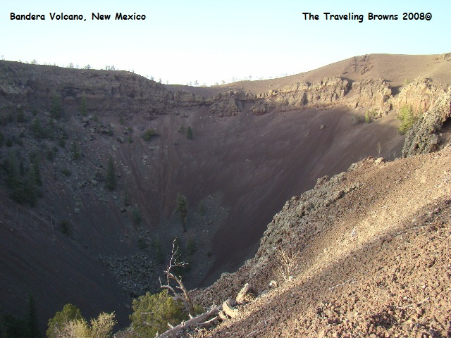
We then lost our heads and
decided to climb to the top of Bandera Volcano.
About half way up we said “what the heck are we doing!!” Remember we had already done about 5 ½ hours
of hiking that day. But, it became a challenge so we forged on. We made it to the top where the wind was
really cracking!! The crater is about
1,200 feet across and 800 feet deep. To
sum it up, it was a BIG WHOOPEE!! We
wouldn’t recommend anyone going out of the way to see it.
The next two days we spent
hunkered down in the RV wondering if it was going to go airborne. Wind hit fifty mph with gusts to sixty. If you did go outside you could hardly breathe
or see due to the blowing dust and sand!
Until next time,
Dave & Barb
The Traveling Browns
Until next time,
Dave & Barb
The Traveling Browns
