Pictures of the Week 2008-32
Hello All,
Departing LaPine we headed north on US97. At Bend we turned west on US20 and followed it all the way to the Oregon coast. US20 takes you up over Santiam Pass and is another one of Oregon’s Scenic Byways. It was a wonderful drive through forests and around lakes, while winding through the steep mountains.
Once reaching the summit of Santiam Pass you are warned by signs the size of billboards about the 6 percent downgrade for eleven miles!! You are not warned once but three times by these big signs with the last one stating FINAL WARNING 6 PERCENT DOWNGRADE NEXT ELEVEN MILES. We just geared down and turned the Tow Boss on and enjoyed the ride down the mountain. It is such a beautiful part of our country.
Once we reached the coast we turned north on US101. At Lincoln City we parked the rig for a week of exploring. Temperatures were in the low 70’s and there wasn’t a cloud in the sky. We couldn’t have asked for anything more. Having grown up in Oregon we know that the weather could have been lousy. We celebrated by going out to dinner and tried to drown ourselves in the famous clam chowder at “Mo’s,” a landmark in this part of the country. After dinner we took a short ride up the Siletz River where we saw a herd of about fifty Roosevelt Elk feeding in a field by the road. It was a perfect ending to the day.
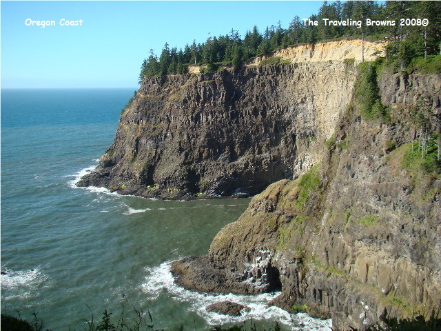
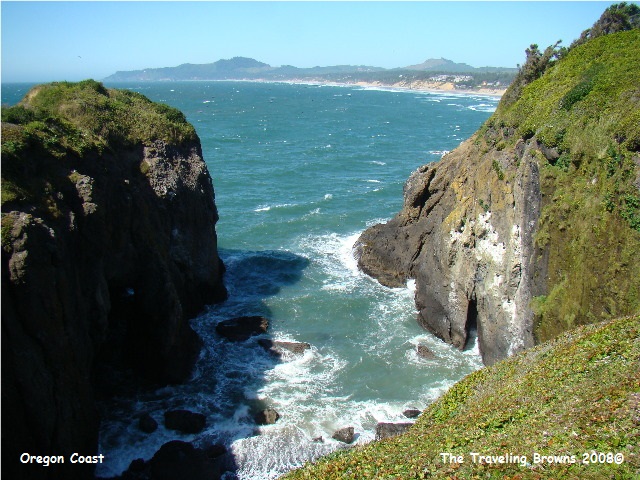
After a good night's sleep we were ready for our first adventure. We decided to drive north along the scenic coast. Oregon’s coastline is very rugged interspersed with beautiful beaches. The State has done an outstanding job in that they have established park after park along the coast. They are to be commended for making this national treasure available to everyone.
Departing LaPine we headed north on US97. At Bend we turned west on US20 and followed it all the way to the Oregon coast. US20 takes you up over Santiam Pass and is another one of Oregon’s Scenic Byways. It was a wonderful drive through forests and around lakes, while winding through the steep mountains.
Once reaching the summit of Santiam Pass you are warned by signs the size of billboards about the 6 percent downgrade for eleven miles!! You are not warned once but three times by these big signs with the last one stating FINAL WARNING 6 PERCENT DOWNGRADE NEXT ELEVEN MILES. We just geared down and turned the Tow Boss on and enjoyed the ride down the mountain. It is such a beautiful part of our country.
Once we reached the coast we turned north on US101. At Lincoln City we parked the rig for a week of exploring. Temperatures were in the low 70’s and there wasn’t a cloud in the sky. We couldn’t have asked for anything more. Having grown up in Oregon we know that the weather could have been lousy. We celebrated by going out to dinner and tried to drown ourselves in the famous clam chowder at “Mo’s,” a landmark in this part of the country. After dinner we took a short ride up the Siletz River where we saw a herd of about fifty Roosevelt Elk feeding in a field by the road. It was a perfect ending to the day.
After a good night's sleep we were ready for our first adventure. We decided to drive north along the scenic coast. Oregon’s coastline is very rugged interspersed with beautiful beaches. The State has done an outstanding job in that they have established park after park along the coast. They are to be commended for making this national treasure available to everyone.
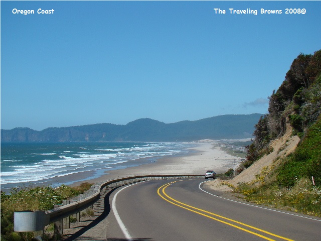
We made stops here and there just to enjoy the
views along with visiting some of the small beach front towns. It goes without saying we snapped lots of
photos. Our final stop northbound was
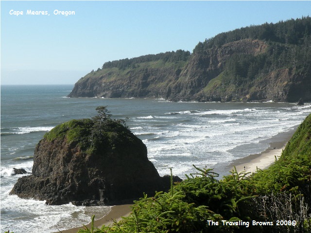
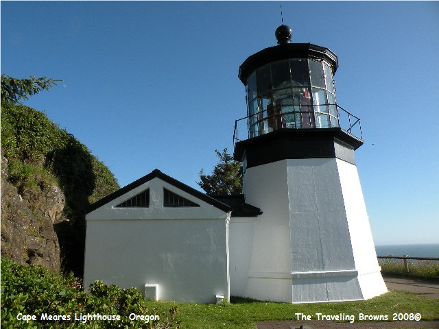
the Cape Meares State Scenic Viewpoint and National Wildlife Refuge. This old lighthouse sits high on the cape and has
helped many a seafarer in the past.
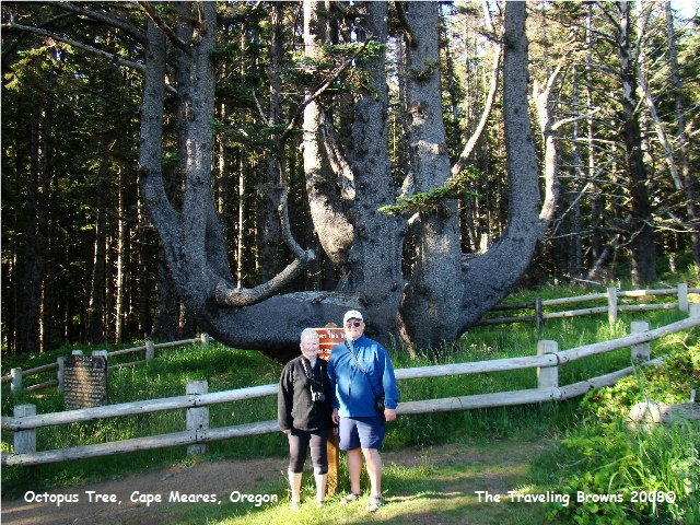
Also at Cape Meares was the “Octopus Tree.” This was a new first for us. It seems this giant old Sitka Spruce didn’t
develop into a massive single trunk tree as most do along the Oregon
coast. The candelabra branching and
unusual size of the tree were formed by strong coastal wind and the sheltered
hollow of its location. Sounds like a
contradiction in points to us. However,
that’s what the experts tell us. Each of
the six candelabra limbs are at least 12 feet around and extend horizontally
from the main trunk as much as 30 feet before turning upward. The base of the tree has a circumference of
about 50 feet. It certainly wasn’t what
you would call a beautiful tree, but it sure was unusual!!
Yup, the next day we followed
the coastline southbound. Our first stop
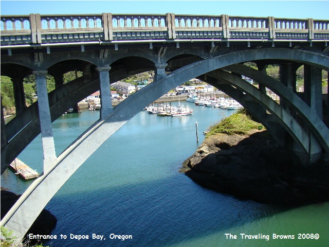
was the little fishing town of Depoe Bay.
While most places boast about having the biggest or the best, Oregon
boasts not only the world’s shortest river, but also the world’s smallest
harbor--the Depoe Bay Harbor!! The entrance to this harbor would frighten any
sane mariner. It is very narrow with large rocks on both sides of the pounding
surf. At times the crashing waves shoot
through natural tubes creating a spray of ocean water that can get so high it
goes over the busy US-101 highway bridge soaking cars and pedestrians
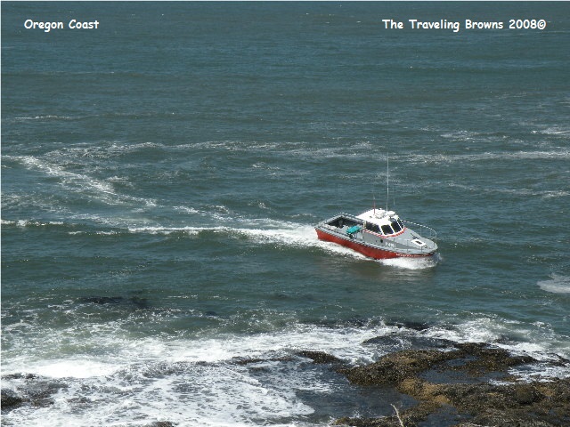
alike!! We watched one boat come into
the harbor entrance. The turbulent water
moved him sideways and dangerously close to the rocks. Can just imagine what it’s like when the wind
really kicks up!!

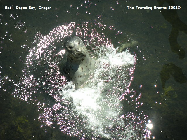
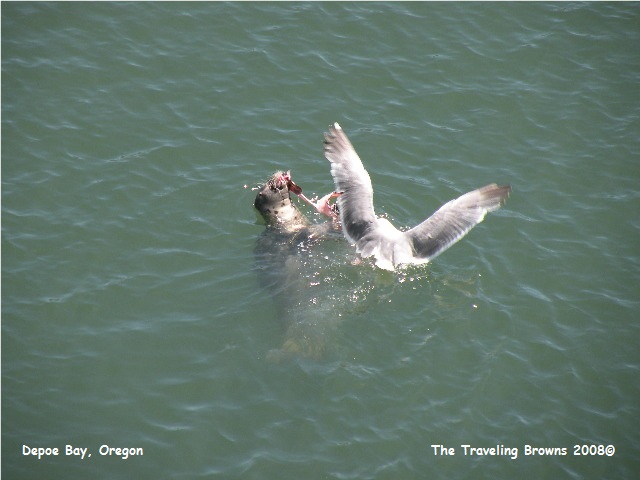
Inside the harbor fishermen
were cleaning their catch when a harbor seal swam up. He put on quite a show clapping his flippers
until the fishermen threw him a scrap.
He would then swim off to eat it.
But, the seagulls wouldn’t let him eat in peace as they would try to
steal it whenever he surfaced!!
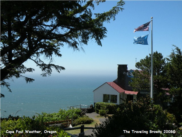
Our next stop was at Cape Foul Weather. It was
discovered by Captain James Cook, the English explorer on March 7, 1778. The weather was particularly stormy on that
day (wind of 100 MPH at the cape is not unusual). Hence, he named the location
Cape Foul Weather. It was the first
geographical location named on his voyage to the Pacific Northwest. The wind was whipping along pretty good on us
also. It had the flags over the gift
shop blowing straight out.
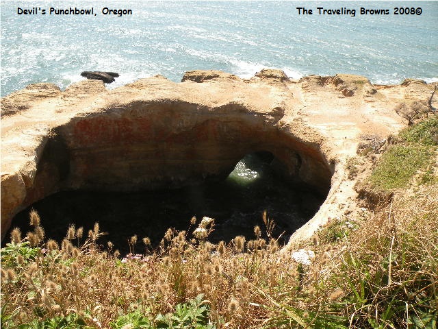
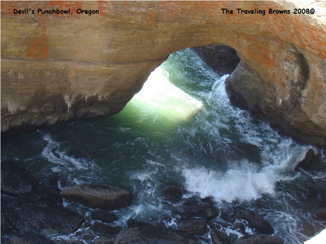
After lunch we continued down
the coast making a stop at Devils Punchbowl.
It is a unique rock formation that really looks like a punchbowl. It was most likely created by the collapse of
the rock roof over two sea caves, then shaped by eroding waves. Water surging into the punchbowl creates a
bubbling, swirling sight that is ever changing with the tide.
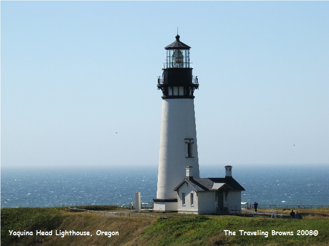
Oregon’s tallest lighthouse, the Yaquina Head
Lighthouse, was our final destination southbound. Standing 93 feet tall, the lighthouse is
situated on a peninsula that juts into the Pacific Ocean. It operates today as it did a century ago. It was built in 1873 and is now fully
automated. After parking the truck in the
parking lot and then stepping out we immediately knew we had a problem. The wind was blowing about 30 MPH!! We donned our coats and started following the
path to the lighthouse which took us past a gorge in the rock peninsula. The northwest wind funneling through the
gorge created a venturi effect that resulted in a wind that almost lifted us
off the ground. It was brutal to say the
least!!
We made a quick visit to the lighthouse and
observed the thousands of seabirds nesting on the rocks below. We followed the lee side of the peninsula
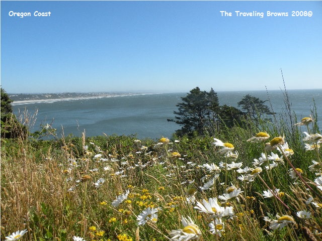
back to the truck, which was somewhat better. However, the wind was still
strong enough that it was literally stripping the petals off of the wild
daisies.
Until next time,
Dave & Barb
The Traveling Browns
Dave & Barb
The Traveling Browns
