Pictures of the Week 2008-26
Hello All,
Departing Page, AZ we headed north on Highway 89 into Utah. We stayed on Highway 89 until intercepting Highway 62. We then followed Highway 62 until it ended at Highway 24 where we turned east. We parked the rig at an RV park in the little town of Torrey, UT. The elevation of the town is 6,800 feet so the temperatures were wonderful.
Waiting to greet us at Torrey were our friends Hal and Rose. They had driven up in their motorhome to spend a couple of days with us. We worked with Hal in Alaska, and when they retired they moved to St. George, UT. Rose had dinner prepared for all of us, and afterwards we spent the evening reliving old times.
Torrey is just a couple of miles from the entrance to Capitol Reef National Park. Since none of the four of us had been to this national park, the next morning we were off and running.
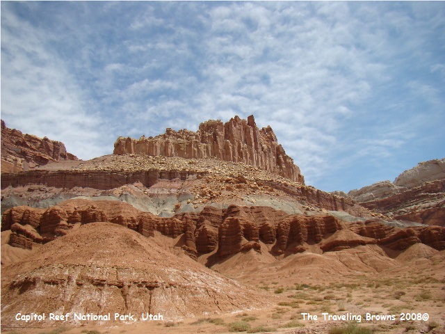
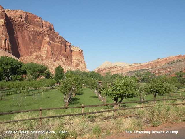
A giant, sinuous wrinkle in the Earth’s crust stretches for 100 miles across south-central Utah. This impressive buckling of rock, created 65 million years ago by the same tremendous forces that later uplifted the Colorado Plateau, is called the Waterpocket Fold. Capitol Reef National Park preserves the fold and its spectacular, eroded jumble of colorful cliffs, massive domes, soaring spires, stark monoliths, twisting canyons, and graceful arches.
Departing Page, AZ we headed north on Highway 89 into Utah. We stayed on Highway 89 until intercepting Highway 62. We then followed Highway 62 until it ended at Highway 24 where we turned east. We parked the rig at an RV park in the little town of Torrey, UT. The elevation of the town is 6,800 feet so the temperatures were wonderful.
Waiting to greet us at Torrey were our friends Hal and Rose. They had driven up in their motorhome to spend a couple of days with us. We worked with Hal in Alaska, and when they retired they moved to St. George, UT. Rose had dinner prepared for all of us, and afterwards we spent the evening reliving old times.
Torrey is just a couple of miles from the entrance to Capitol Reef National Park. Since none of the four of us had been to this national park, the next morning we were off and running.
A giant, sinuous wrinkle in the Earth’s crust stretches for 100 miles across south-central Utah. This impressive buckling of rock, created 65 million years ago by the same tremendous forces that later uplifted the Colorado Plateau, is called the Waterpocket Fold. Capitol Reef National Park preserves the fold and its spectacular, eroded jumble of colorful cliffs, massive domes, soaring spires, stark monoliths, twisting canyons, and graceful arches.
Life in the Waterpocket Fold
country is most abundant along the Fremont River. American Indians, early pioneers,
moisture-loving plants, and many animals have all found refuge near its waters. Explorers, Mormon pioneers, and others began
to make their way into the valley of the Fremont River in the late 1800s. Settling beyond the valley required a trip
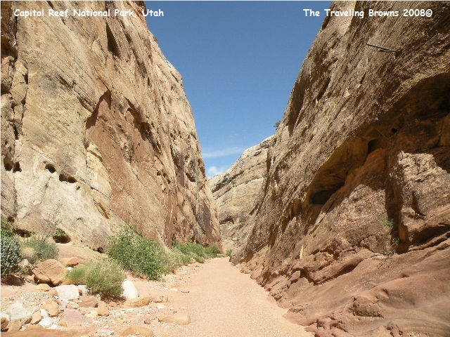
across the rough terrain of the Waterpocket Fold. Capitol Gorge is a narrow, rocky route that
cuts through the fold. One rock wall in
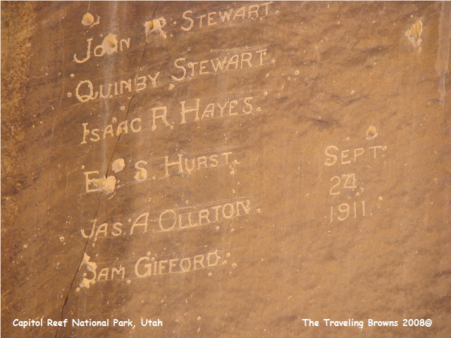
the gorge is called Pioneer Register. It is filled with the names of miners,
settlers, and others who passed through this canyon beginning in 1871.
If you look closely at the following photo you can see a horizontal pipe coming out of the rock in the upper right corner. Pipes like this were about every 100 feet throughout the gorge. They stuck out of the rock about 2½ feet and were about 12 feet above the ground. We just couldn’t figure out what they were for. Finally, we asked a park ranger who informed us that they were for telephone lines. Since the gorge periodically suffered flash floods, telephone poles would have been washed away. So settlers strung the lines on these pipes. Makes sense doesn‘t it!!
If you look closely at the following photo you can see a horizontal pipe coming out of the rock in the upper right corner. Pipes like this were about every 100 feet throughout the gorge. They stuck out of the rock about 2½ feet and were about 12 feet above the ground. We just couldn’t figure out what they were for. Finally, we asked a park ranger who informed us that they were for telephone lines. Since the gorge periodically suffered flash floods, telephone poles would have been washed away. So settlers strung the lines on these pipes. Makes sense doesn‘t it!!
By 1917 the tiny Mormon community of Fruita,
known for its productive orchards, was bustling on the banks of the Fremont
River. After Capitol Reef was set aside
as a national park in 1937, the farmers and their families gradually moved
away. Today life along the Fremont River
consists of orchards, cottonwoods, willows, and ash. There we saw two of the largest gnarly old
cottonwood trees we have ever seen.
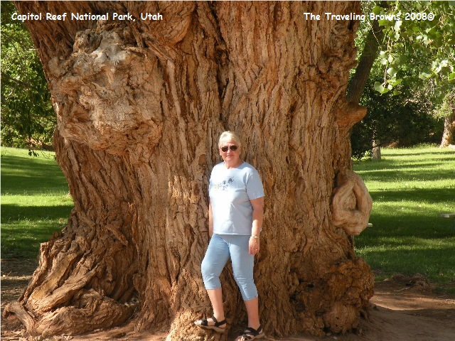
The orchards are still
thriving and being maintained by the park service. When in season you can eat
the fruit free of charge. However, there
is a fee for any you bag up and take with you.
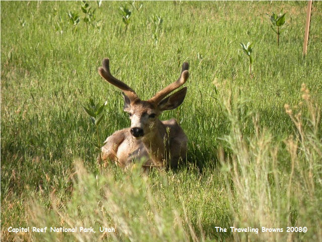
During our short visit we saw a golden eagle, coyote, marmots, and mule
deer in the green ribbon of land along the river. But, move away from the river even just a few
hundred yards and the harsh, sparser environment of the desert dominates.
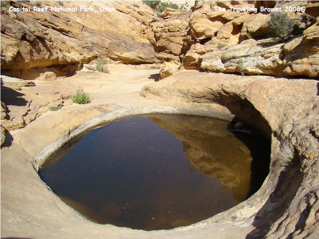
Occasionally pools of
rainwater collect in eroded bowl-like depressions in the rock called
waterpockets. Oddly, the tiny
waterpocket is the namesake of the massive fold that dominates this
landscape. Bighorn sheep, bobcats, and
even people have quenched their thirst at these holes.
After a full day in the park
we were starved. We had made a long hike
up through Capitol Gorge and we were pooped.
We all agreed we were going to eat dinner out. The options in Torrey are rather
limited. We stopped at one place and
were quickly seated. The first entrée on
the menu was rattlesnake cakes!! The
second was coconut calamari!! It went
downhill from there. And, they were real
proud of their selections. We excused
ourselves prior to ordering and found another restaurant down the street!
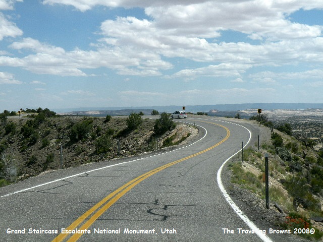
After a good nights sleep we decided to do a driving loop through Grand Staircase-Escalante to Red Canyon and back to Torrey. Well, it seems the driver missed our turn onto the proper highway (that would be Dave). Since the countryside was new to all of us we didn’t discover the error until we were forty miles down the wrong road! We all had a good laugh and then stopped and had lunch before backtracking to the proper highway.
It was a spectacular drive with varied scenery the entire loop. Traveling south on Highway 12 out of Torrey, we soon began to climb, and climb, and climb. We drove through high mountain meadows adorned by ponderosa pine and aspen forests. The summit of the pass was at 9600 feet. Needless to say, the viewpoints along the way were pretty spectacular of the Capitol Reef area and the beautiful valley we had just left.
We came out of the mountains into the small town of Boulder. South of Boulder we again climbed and re-entered Grand Staircase-Escalante. The highway was winding its way on a very narrow razorback with deep canyons on both sides of us. It was quite amazing in places.
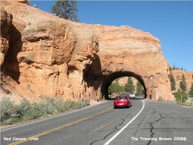
Red Canyon, located just past
the entrance to Bryce Canyon, has some of the most beautiful landscapes. The scenic highway cuts through the red
sandstone in a couple of places. We had
been there some years ago when we visited Bryce Canyon; but we enjoyed it so much
we wanted to experience it again.

After two fun filled days we
bid our friends farewell. They returned
to St. George and we did more mundane things like laundry, bills, and washing
the truck.
Until next time,
Dave & Barb
The Traveling Browns
Until next time,
Dave & Barb
The Traveling Browns
