2013-7 Bryce National Park, Utah
Hello All,
Our next adventure found us at Bryce Canyon National Park located in southwest Utah about 50 miles northeast of and 1,000 feet higher than Zion National Park. Therefore, the weather in Bryce Canyon is cooler and the park receives a total of 15 to 18 inches of precipitation a year.
The canyon was settled by Mormon pioneers in the 1850s and named after Ebenezer Bryce, who homesteaded in the area in 1874. In 1923, the area around Bryce Canyon became a National Monument and then was designated as a National Park in 1928. It receives relatively few visitors compared to Zion and Grand Canyon National Parks, largely due to its remote location.
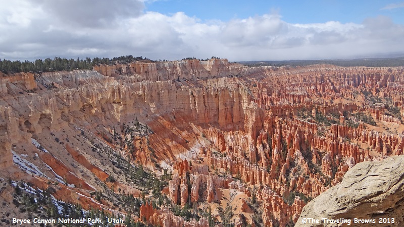
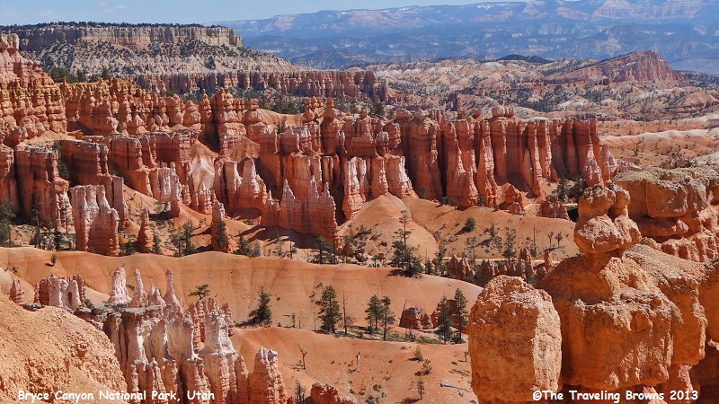
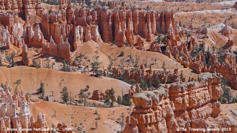
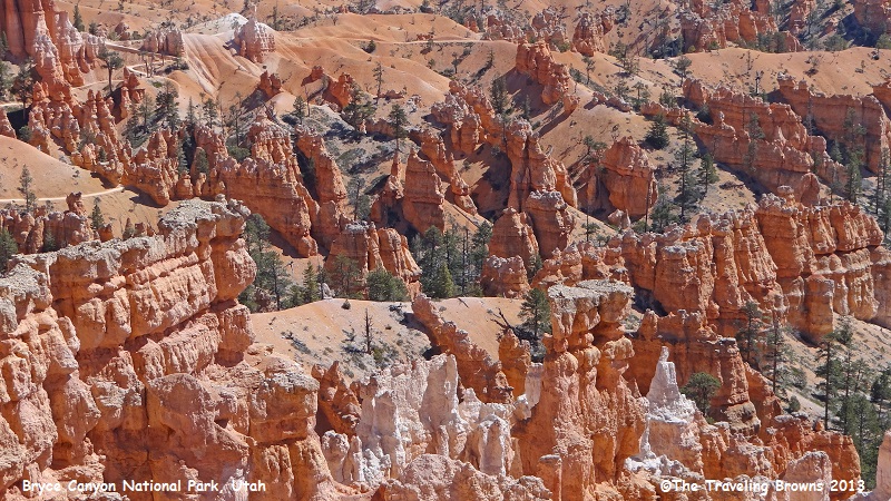
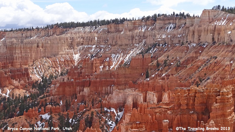
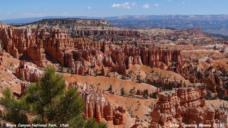
Bryce Canyon is the major feature of the park, which despite its name, is not a canyon but a collection of giant natural amphitheaters along the eastern side of the Paunsaugunt Plateau. It is distinctive due to geological structures called hoodoos. The red, orange, and white colors of the rocks provide spectacular views for park visitors. Thousands of delicately carved hoodoos rise in brilliant colors from the amphitheaters. Some hoodoos are up to 200 feet high. Millions of years of wind, water, and geologic mayhem have also shaped and etched the pink cliffs at Bryce. Hoodoos can be found on every other continent, but in no place can you find the sheer numbers like at Bryce. A series of amphitheaters extend for more than 20 miles within the park--the largest of which is Bryce Amphitheater, which is 12 miles long, 3 miles wide, and 800 feet deep.
The park also has a 7.4 magnitude night sky, making it one of the darkest in North America. Stargazers can therefore see 7,500 stars with the naked eye, while in most places fewer than 2,000 can be seen due to light and air pollution. In many large cities only a few dozen stars can be seen at night.
Since it had been a number of years since our last visit to Bryce Canyon we decided to stay for three days. This would give us plenty of time to take in the canyon and explore other areas surrounding the park.
The 18-mile dead end rim scenic drive is an excellent way to get a great overview of the park. There are 13 viewpoints on this paved drive. A recommended way of taking it all in is to drive to the end of the road and then stop at all 13 viewpoints on the return drive. The canyon and all viewpoints will be on your right on the return trip. Of course we stopped at most of them on the way in and again on the way out because of the ever changing light and sky conditions. The rim at Bryce varies from 8,000 to slightly more than 9,000 feet in elevation.
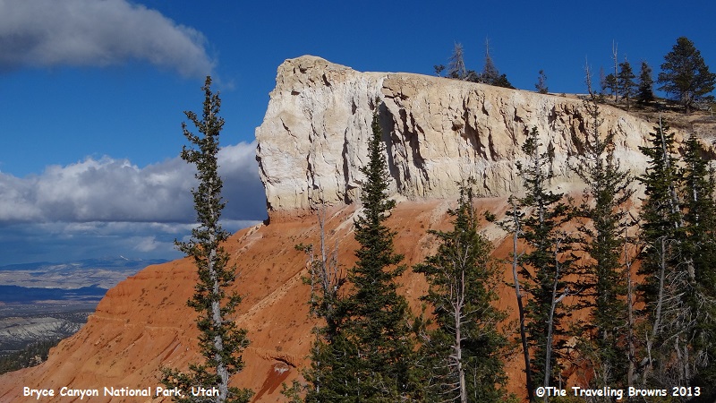
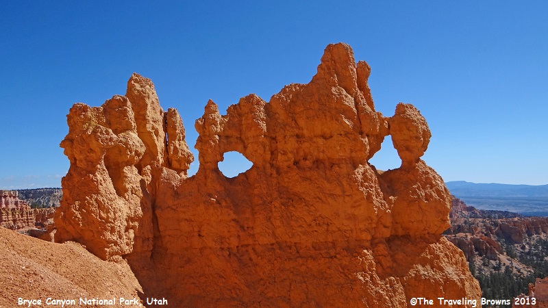
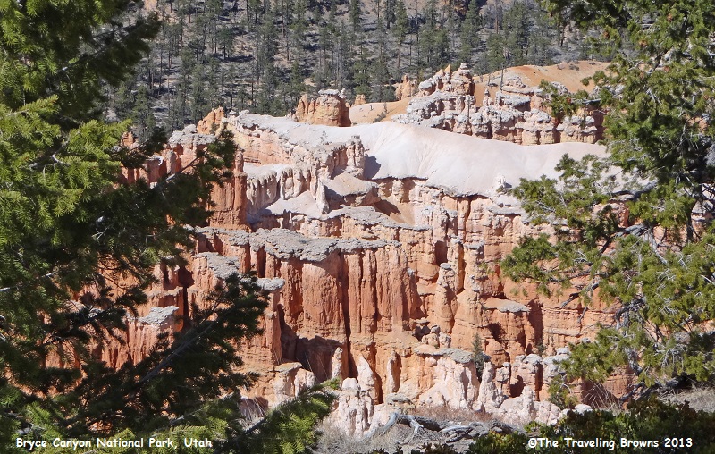
On the first day as we were working our way back to the park entrance we passed this rock cliff with stark contrasting color and just couldn’t resist snapping some photos.
Our next adventure found us at Bryce Canyon National Park located in southwest Utah about 50 miles northeast of and 1,000 feet higher than Zion National Park. Therefore, the weather in Bryce Canyon is cooler and the park receives a total of 15 to 18 inches of precipitation a year.
The canyon was settled by Mormon pioneers in the 1850s and named after Ebenezer Bryce, who homesteaded in the area in 1874. In 1923, the area around Bryce Canyon became a National Monument and then was designated as a National Park in 1928. It receives relatively few visitors compared to Zion and Grand Canyon National Parks, largely due to its remote location.
Bryce Canyon is the major feature of the park, which despite its name, is not a canyon but a collection of giant natural amphitheaters along the eastern side of the Paunsaugunt Plateau. It is distinctive due to geological structures called hoodoos. The red, orange, and white colors of the rocks provide spectacular views for park visitors. Thousands of delicately carved hoodoos rise in brilliant colors from the amphitheaters. Some hoodoos are up to 200 feet high. Millions of years of wind, water, and geologic mayhem have also shaped and etched the pink cliffs at Bryce. Hoodoos can be found on every other continent, but in no place can you find the sheer numbers like at Bryce. A series of amphitheaters extend for more than 20 miles within the park--the largest of which is Bryce Amphitheater, which is 12 miles long, 3 miles wide, and 800 feet deep.
The park also has a 7.4 magnitude night sky, making it one of the darkest in North America. Stargazers can therefore see 7,500 stars with the naked eye, while in most places fewer than 2,000 can be seen due to light and air pollution. In many large cities only a few dozen stars can be seen at night.
Since it had been a number of years since our last visit to Bryce Canyon we decided to stay for three days. This would give us plenty of time to take in the canyon and explore other areas surrounding the park.
The 18-mile dead end rim scenic drive is an excellent way to get a great overview of the park. There are 13 viewpoints on this paved drive. A recommended way of taking it all in is to drive to the end of the road and then stop at all 13 viewpoints on the return drive. The canyon and all viewpoints will be on your right on the return trip. Of course we stopped at most of them on the way in and again on the way out because of the ever changing light and sky conditions. The rim at Bryce varies from 8,000 to slightly more than 9,000 feet in elevation.
On the first day as we were working our way back to the park entrance we passed this rock cliff with stark contrasting color and just couldn’t resist snapping some photos.
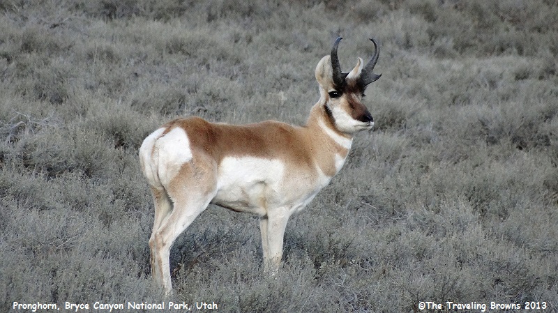
A few miles further up the
road we came across a male pronghorn running across the countryside. We snapped
a few photos that all turned out blurry! They can run exceptionally fast and
are generally accepted to be the second fastest land mammal—second only to the
cheetah. A pronghorn’s top speed is about 55 mph. However, they can sustain
high speeds much longer than a cheetah. They are also known to be quite
curious. Were we ever pleasantly surprised when he stopped to check us out,
which afforded us the opportunity to take photos. He looked awesome in his
thick winter coat.
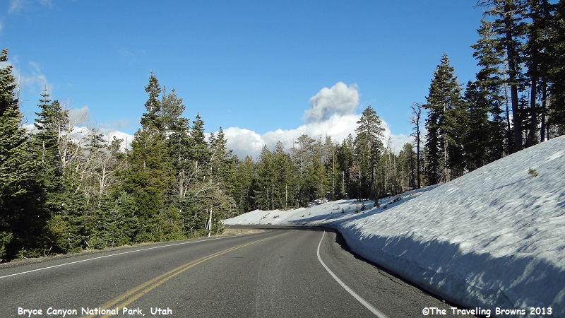
As we climbed up above the
9,000-foot level on the rim road there were still areas with evidence of winter
along the road. It made for a beautiful drive.
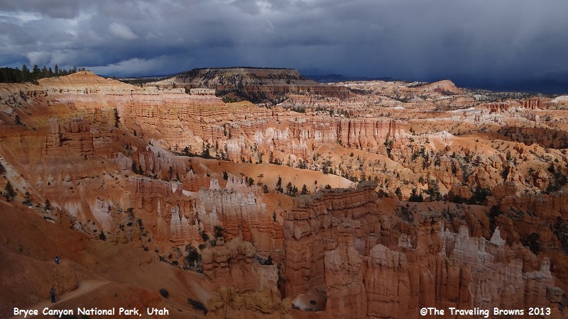
As we continued making our way
back downhill, stopping at viewpoints along the way, clouds began moving in
rapidly and started covering the bright blue sky—bummer! We did our best to
snap a few photos but the weather was deteriorating rapidly.
It wasn’t long before the
handwriting was on the wall. There was a heck of a storm moving into the area.
We did a beeline back to our lodging and called it a day. The cold front was
forecast to pass through the area overnight, so we had our fingers crossed that
it would keep moving away before morning.
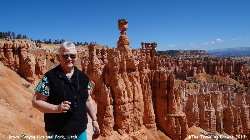
When we awoke the next morning there was blue
sky every direction we looked—perfect. Our first stop was the Bryce
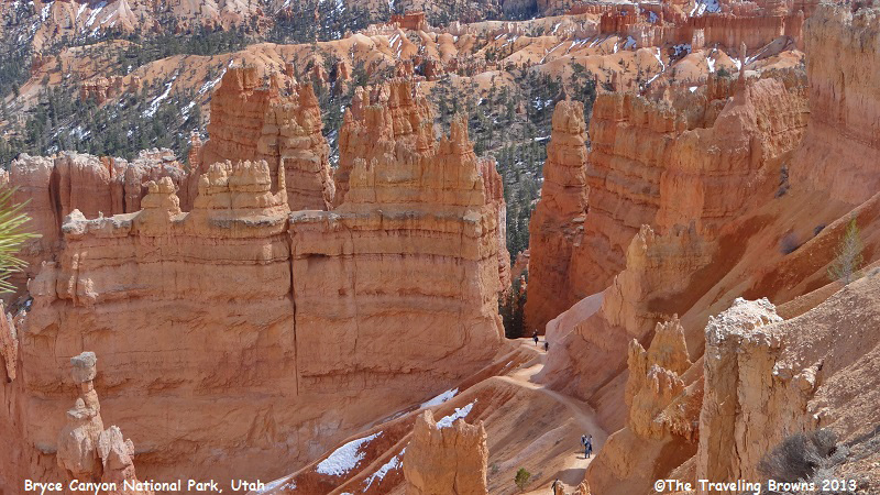
Amphitheater where we decided to take the trail down into the hoodoos. It was
awesome—like being in another world. Here is Barb in front of the hoodoo named
Thor’s Hammer.
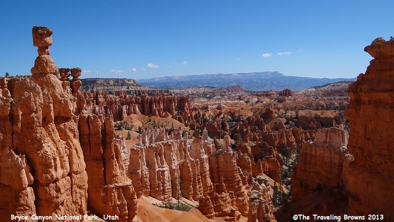
Trails wind down into
spectacular areas in and around the hoodoos. We would highly recommend that
anyone visiting Bryce take a trail down into them. Every turn offers a new
vista.
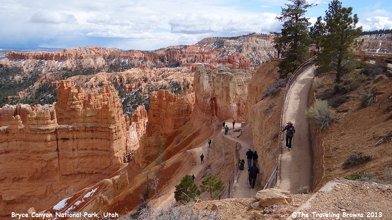
If you look closely you can
see the trail snaking around the landscape in the following photos.
This is a unique formation and
one of our personal favorites.
Here’s a shot looking back
towards the rim of the amphitheater. As you can see there are patches of snow
scattered around.
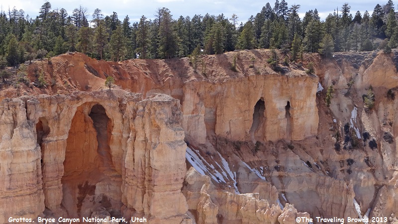
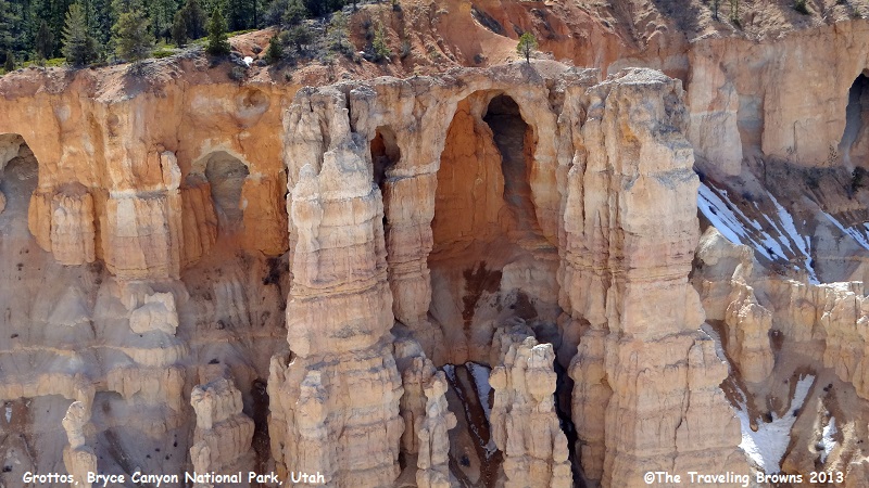
Along the edge of the rim is a
pattern of formations known as grottos. Erosion working on the different types
of rock creates amazing alcoves and windows that change in appearance depending
upon the light conditions of the day.
After climbing back up the
trail we continued our drive along the rim road. In the following photo you
will notice the hoodoos in the bottom right quarter appear to be capped with
what looks like concrete. It is an amazing all natural phenomena of Mother Nature.
Here is another area where
hoodoos appear to be capped with concrete.
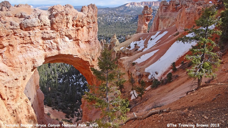
We made a stop at the landmark
known as Natural Bridge. The park service has a sign there stating the bridge
is misnamed—technically it is an arch. Natural bridges are carved by rushing
streams whereas subtler forms of weather sculpted this opening. Whatever it is,
we thought it made for a nice photo!
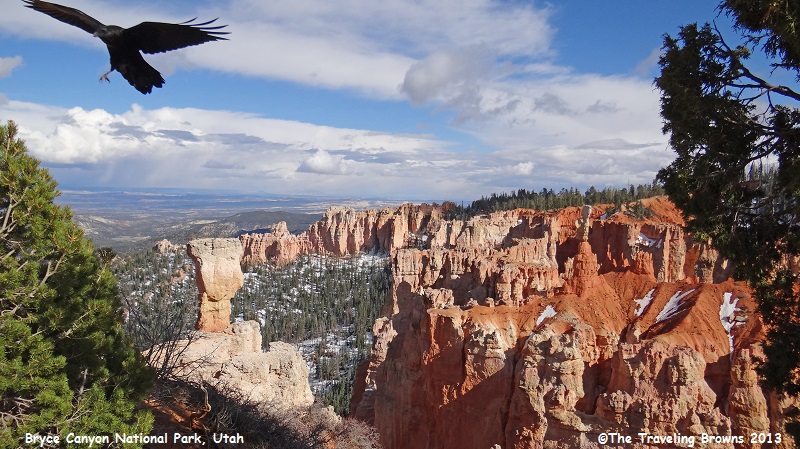
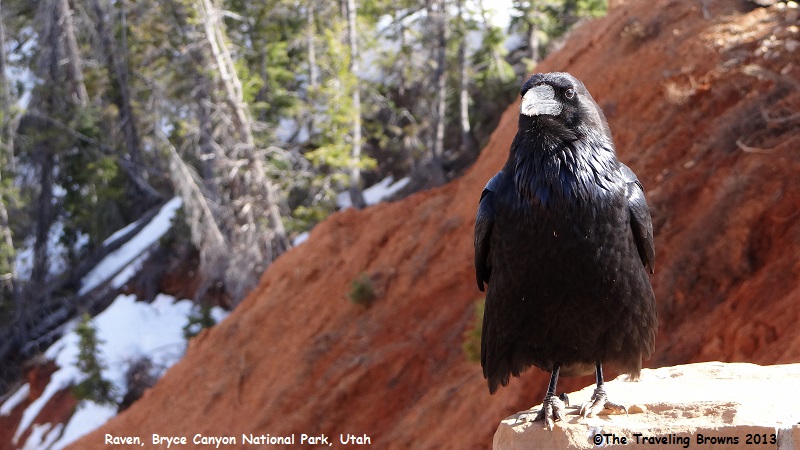
As we stopped at the different
viewpoints we developed quite a relationship with the raven in the following
photos. He evidently thought we were easy targets for a free meal. Though we
never fed him he was persistent. After taking photos at one viewpoint we would
get back in the car and drive a mile or so to the next viewpoint. About the
time we got out of the car he would fly in and land near us. Ravens are known
for being smart and bold.
We first visited Bryce Canyon
National Park in October of 1996. It was a beautiful fall day. We struck up a
conversation with a park ranger and he advised us that it was the perfect time
to visit. He stated most people visit during the summer and are faced with
almost daily thunderstorms. His recommendation as the ideal times to visit the
park were early spring or late fall. We never forgot his advice, and so we pass
it on to you.
Until next time,
Dave & Barb
The Traveling Browns
Until next time,
Dave & Barb
The Traveling Browns
