Pictures of the Week 2008-28
Hello All,
With Dave feeling better we decided to pick up and move on down the road. We followed I-15 north to Beaver, UT and then turned west on Highway 21. Stayed on Highway 21 to Garrison, UT; jogged north on Highway 159; and then turned west on US 50. We crossed into Nevada and stopped at the town of Ely, NV for a few days of exploring.
Our first adventure was to Great Basin National Park east of Ely. The Great Basin is a vast area of sagebrush-covered valleys and narrow mountain ranges. The name comes from a peculiarity of drainage: over most of the area, streams and rivers find no outlet to the sea. Instead, water collects in shallow salt lakes, marshes, and mud flats, where it evaporates in dry desert air. There is not just one basin but many, all separated by mountain ranges running roughly parallel, north to south. The Great Basin is centered in Nevada but extends into neighboring Utah, Idaho, Oregon and California.
Great Basin National Park was established in 1986 to preserve a portion of the basin. It is a superb example of a desert mountain island. From the sagebrush at its alluvial base to the 13,063 foot summit of Wheeler Peak, the park includes streams, lakes, alpine plants, abundant wildlife, a variety of forest types, including groves of ancient bristlecone pines, and numerous limestone caverns. Bristlecone pines grow between 9,500 and 11,000 feet. A bristlecone pine found in the park has been determined to be the world’s oldest living tree at 4,950 years of age.
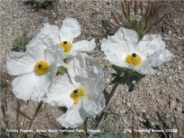
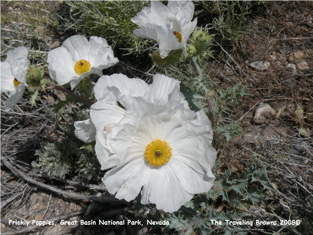
At the lower levels of the park there was an unusual flower in bloom. They were white with yellow centers and generally found in clusters. We had never seen anything like them. Turns out they are Prickly Poppies.
With Dave feeling better we decided to pick up and move on down the road. We followed I-15 north to Beaver, UT and then turned west on Highway 21. Stayed on Highway 21 to Garrison, UT; jogged north on Highway 159; and then turned west on US 50. We crossed into Nevada and stopped at the town of Ely, NV for a few days of exploring.
Our first adventure was to Great Basin National Park east of Ely. The Great Basin is a vast area of sagebrush-covered valleys and narrow mountain ranges. The name comes from a peculiarity of drainage: over most of the area, streams and rivers find no outlet to the sea. Instead, water collects in shallow salt lakes, marshes, and mud flats, where it evaporates in dry desert air. There is not just one basin but many, all separated by mountain ranges running roughly parallel, north to south. The Great Basin is centered in Nevada but extends into neighboring Utah, Idaho, Oregon and California.
Great Basin National Park was established in 1986 to preserve a portion of the basin. It is a superb example of a desert mountain island. From the sagebrush at its alluvial base to the 13,063 foot summit of Wheeler Peak, the park includes streams, lakes, alpine plants, abundant wildlife, a variety of forest types, including groves of ancient bristlecone pines, and numerous limestone caverns. Bristlecone pines grow between 9,500 and 11,000 feet. A bristlecone pine found in the park has been determined to be the world’s oldest living tree at 4,950 years of age.
At the lower levels of the park there was an unusual flower in bloom. They were white with yellow centers and generally found in clusters. We had never seen anything like them. Turns out they are Prickly Poppies.
Of all the national parks we
have visited, Great Basin would be our least favorite. Not because of the subject matter, but how it
is being maintained by the Park Service.
The café at the visitors' center is advertised as being open from April
to October. Yup, it was closed!! We always carry food with us, but a family
could have been caught short! Overlooks
are not well maintained. Brush and trees
have grown to the point of obstructing views.
Nor are they laid out well for viewing highlights within the park.
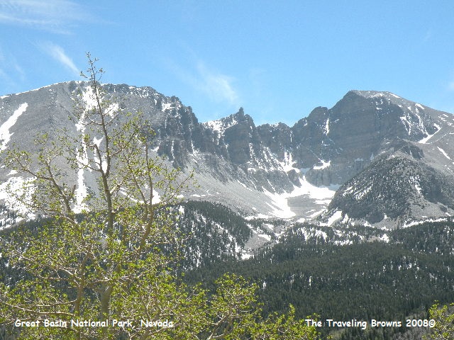
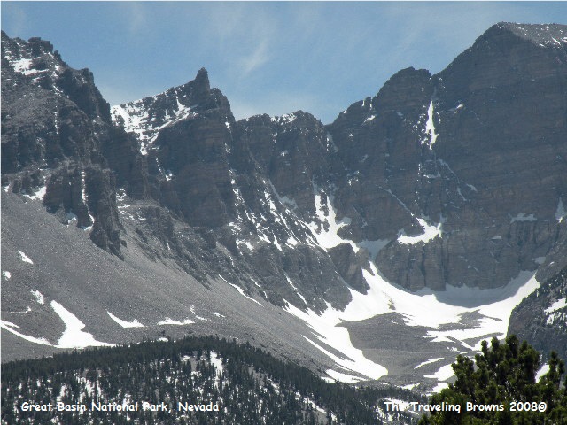
There is a 15-mile scenic drive in the park. It gets your attention immediately with a sign that says: Eight percent grade next 12 miles - No passing - Narrow road - 25 MPH speed limit!! And they weren’t kidding; it switches back and forth up the mountain with no guard rails--starting at 6,000 feet and ending above 10,000 feet. It ends at a bowl made by Jeff Davis Peak 12,771 feet, Wheeler Peak 13,063, and Bald Mountain 11,562 feet. Again, at the end of the road there was no viewing area of the bowl. You had to take off on the summit trail to reach an area to view the bowl. We didn’t think we wanted to start a hike above 10,000 feet. We had to work hard to get shots of the bowl.
There is a 15-mile scenic drive in the park. It gets your attention immediately with a sign that says: Eight percent grade next 12 miles - No passing - Narrow road - 25 MPH speed limit!! And they weren’t kidding; it switches back and forth up the mountain with no guard rails--starting at 6,000 feet and ending above 10,000 feet. It ends at a bowl made by Jeff Davis Peak 12,771 feet, Wheeler Peak 13,063, and Bald Mountain 11,562 feet. Again, at the end of the road there was no viewing area of the bowl. You had to take off on the summit trail to reach an area to view the bowl. We didn’t think we wanted to start a hike above 10,000 feet. We had to work hard to get shots of the bowl.
We were quite pleased with the
performance of our diesel truck.
Climbing the steep grade we just geared her down and she purred along
with no stress and didn’t even get warm.
Coming down we set up the Tow Boss to hold her at 25 mph and didn’t have
to touch the brakes except in extreme cases.
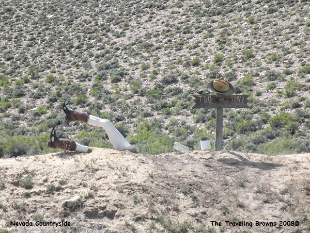
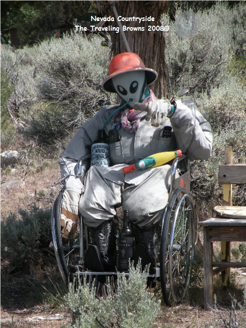
While traveling the southwestern states we have come across some of the strangest things out in the middle of nowhere. Nevada was no different as shown in the following two photos. The sign on the first one says: Two Tall Toni. We’re not sure what the significance of these creations is, but we always find them interesting.
While traveling the southwestern states we have come across some of the strangest things out in the middle of nowhere. Nevada was no different as shown in the following two photos. The sign on the first one says: Two Tall Toni. We’re not sure what the significance of these creations is, but we always find them interesting.
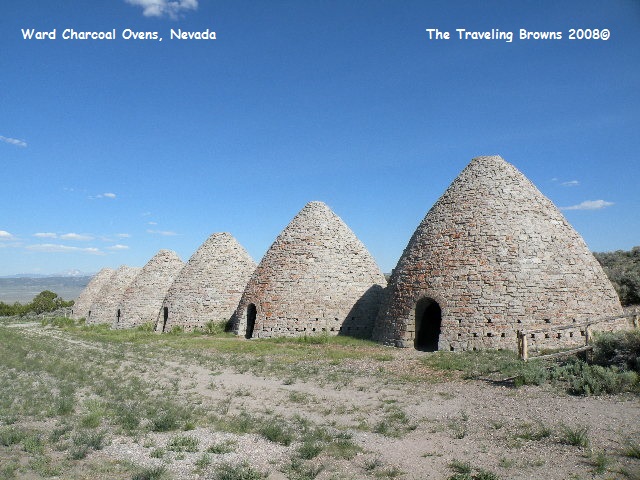
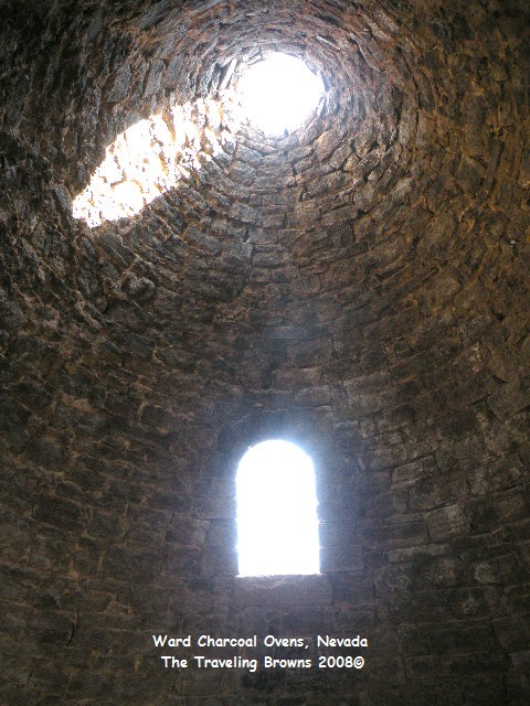
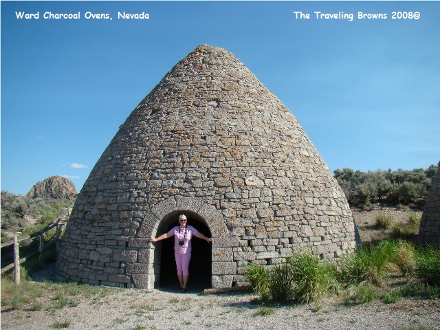
On the return trip to Ely we
decided to stop at Ward Charcoal Ovens State Park. We followed a dirt road for 10 miles to reach
the park. Wow, was it dusty--you could
see a car coming for miles! Upon reaching the park we were the only ones
there. We had never seen anything like
this--it was fascinating.
These ovens were constructed in the mid 1870’s by Italian masons. They are larger and of finer construction than other ovens found in Nevada. Each of the six ovens is 27 feet in diameter and 30 feet high with a capacity of about 35 cords of wood, which was burned for a period of 12 days to produce about 50 bushels of good solid charcoal per cord.
The charcoal was used in the smelters at nearby Ward. About 30 to 50 bushels are required to reduce one ton of ore. Each filling of one of these ovens required the total tree crop from 5 or 6 acres of land. During the late 1870’s the hills and mountains around many mining camps were completely striped of all timber for a radius of up to 35 miles.
As railroads penetrated the west, charcoal was replaced by coke made from coal, and the charcoal industry faded.
Having spent nearly two months
in the southwestern “desert” states we plan to put the pedal to the metal as
they say and boogie to the Pacific Northwest.
Until next time,
Dave & Barb
The Traveling Browns
Until next time,
Dave & Barb
The Traveling Browns
