2013-25 Yoho National Park, Canada
Hello All,
Our next adventure in the Canadian Rockies took us to Yoho National Park. Departing Banff Village we followed the Trans-Canada Highway northwest up and over Kicking Horse Pass and the Continental Divide of Canada. The divide is the border between the provinces of British Columbia and Alberta. Yoho is located on the western side of the divide in British Columbia and is often skipped by folks visiting Jasper and Banff National Parks in Alberta.
Established in 1886, Yoho is one of 43 national parks in Canada. The name Yoho comes from the Cree Indian word for awe and wonder.
One of the most interesting places within Yoho National Park is virtually not photographable. It is known as the Spiral Tunnels. Here is a brief background of the tunnels.
When British Columbia joined Canada in 1871, it was on the
condition that the government would build a railway to link the province to the
rest of the country. Kicking Horse Pass was chosen as the location for the new
railroad to cross the Rocky Mountain Range.
Kicking Horse Pass and its steep grade posed a serious challenge. Under government pressure to complete the railway, and given the engineering challenges that came along with the geography, Canadian Pacific Railway was not in a position to carve a gradual descent down the western slope.
A solution was reached, which temporarily allowed a grade of 4.5%. The first train to attempt the hill in 1884 derailed, tragically killing three workers. In an effort to improve safety, three spur lines were created to divert such runaway trains on what became known as the “Big Hill.” Switches were left set for the spurs and were not reset to the main line until switchmen knew the oncoming train was in control. Descending the Big Hill was challenging, but uphill trains had their problems too. Extra locomotives were needed to push the trains up the hill, causing delays and requiring extra workers.
Runaway trains were common on the Big Hill. An old-timer described the spur lines on the Big Hill as places where “…wrecks could take place without hindering traffic on the mainline.” One engineer decided not to use them to stop his runaway train. He whistled long and loudly at each switch—the signal for each switchman to let him through. The train sped crazily down the track. Arriving triumphantly at the little town at the base of the Big Hill, the engineer discovered a telegram marked “rush” awaiting him. He was, it stated, fired for disregarding the rules!
The solution for a more gradual grade came from J.E.Schwitzer, one of the railway’s Assistant Chief Engineers. He modeled the Spiral Tunnels after a system used in Switzerland.
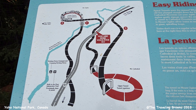
The route decided upon called for two tunnels driven in three-quarter circles into the narrow valley walls. The higher tunnel, "number one," was about one thousand yards in length and ran under Cathedral Mountain, to the south of the original track. When the new line emerged from this tunnel it had doubled back, running beneath itself and 50 feet lower. It then descended the valley side in almost the opposite direction to its previous course before crossing the Kicking Horse River and entering Mount Ogden to the north. This lower tunnel, "number two," was a few yards shorter than "number one" and the descent was again about fifty feet. From the exit of this tunnel the line continued down the valley in the original direction. The construction and extra track effectively doubled the length of the climb and reduced the ruling gradient from 4.5% to 2.2%.
In 1909 the Spiral Tunnels were completed and after 25 years of use, the Big Hill grade was abandoned. With a gentler grade, descents became safer and slower, spur lines and rear pushers were no longer necessary, and scheduling delays and operating costs were reduced.
Kicking Horse Pass and its steep grade posed a serious challenge. Under government pressure to complete the railway, and given the engineering challenges that came along with the geography, Canadian Pacific Railway was not in a position to carve a gradual descent down the western slope.
A solution was reached, which temporarily allowed a grade of 4.5%. The first train to attempt the hill in 1884 derailed, tragically killing three workers. In an effort to improve safety, three spur lines were created to divert such runaway trains on what became known as the “Big Hill.” Switches were left set for the spurs and were not reset to the main line until switchmen knew the oncoming train was in control. Descending the Big Hill was challenging, but uphill trains had their problems too. Extra locomotives were needed to push the trains up the hill, causing delays and requiring extra workers.
Runaway trains were common on the Big Hill. An old-timer described the spur lines on the Big Hill as places where “…wrecks could take place without hindering traffic on the mainline.” One engineer decided not to use them to stop his runaway train. He whistled long and loudly at each switch—the signal for each switchman to let him through. The train sped crazily down the track. Arriving triumphantly at the little town at the base of the Big Hill, the engineer discovered a telegram marked “rush” awaiting him. He was, it stated, fired for disregarding the rules!
The solution for a more gradual grade came from J.E.Schwitzer, one of the railway’s Assistant Chief Engineers. He modeled the Spiral Tunnels after a system used in Switzerland.
The route decided upon called for two tunnels driven in three-quarter circles into the narrow valley walls. The higher tunnel, "number one," was about one thousand yards in length and ran under Cathedral Mountain, to the south of the original track. When the new line emerged from this tunnel it had doubled back, running beneath itself and 50 feet lower. It then descended the valley side in almost the opposite direction to its previous course before crossing the Kicking Horse River and entering Mount Ogden to the north. This lower tunnel, "number two," was a few yards shorter than "number one" and the descent was again about fifty feet. From the exit of this tunnel the line continued down the valley in the original direction. The construction and extra track effectively doubled the length of the climb and reduced the ruling gradient from 4.5% to 2.2%.
In 1909 the Spiral Tunnels were completed and after 25 years of use, the Big Hill grade was abandoned. With a gentler grade, descents became safer and slower, spur lines and rear pushers were no longer necessary, and scheduling delays and operating costs were reduced.
Talking about
getting derailed! It’s time we got back on point with our write-up. Before we
move on we should note, there is a viewpoint where you can see the entrances of
the Spiral Tunnels in the mountainsides and there are numerous historical signs
telling all about them. It is quite interesting and worth a stop. You can
observe trains entering and exiting the tunnels.
Here is an overview sign showing the layout of the tunnels.
Here is an overview sign showing the layout of the tunnels.
Our first
target destination in the park was Takakkaw Falls. We turned onto Yoho Valley
Road and followed it to the end. At first it appears to be a nice two-lane road
following the path of the Yoho River. It made us wonder why there was a sign at
the turn off advising that the road was not suitable for campers and trailers—maybe
it was the narrow bridges.
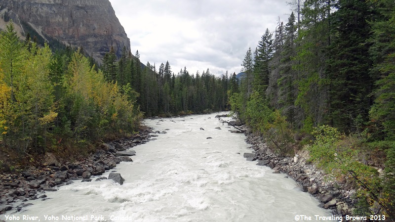
It was an
overcast day on the western side of the Continental Divide. But, we didn’t let
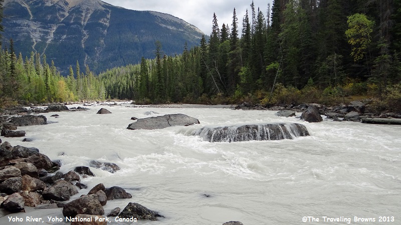
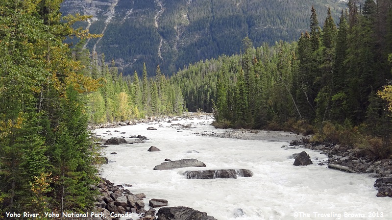
that put a damper on our day of exploring. The Yoho River is laden with glacial
silt making the water appear a milky white color. We have seen a lot of silt
laden rivers, especially in Alaska, but none to this extent.
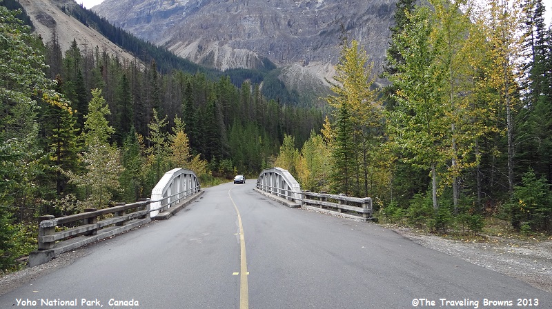
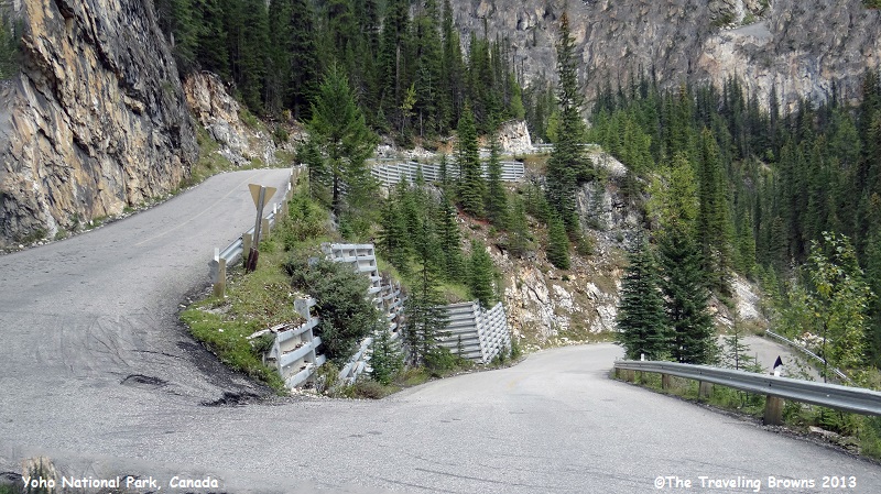
It wasn’t long before we learned why the road wasn’t suitable for
recreation vehicles. Building a road through this narrow steep mountain valley
offered the same challenges the builders of the railroad faced. In this photo
you can see the road coming uphill on the right side and then do a 180-degree switchback,
then do another 180-degree switchback at the point where we are taking the
shot, before proceeding up the mountain. Throw in a few potholes with the steep
grade and switchbacks, and it would be rough going for a recreation vehicle.
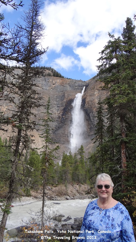
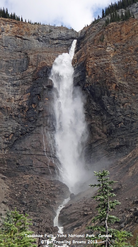
Upon reaching
our destination we found Takakkaw Falls to be spectacular. Water flowing over
the falls is fed by the Daly Glacier, which is part of the Waputik Icefield. In
Cree Takakkaw means “magnificent” and is it ever!
At a height of 1260’ it is one of the highest waterfalls in Canada. The water falls down a shoot and then hits a rock ledge where it explodes out before continuing to fall down the mountainside. It was most unusual and impressive!
At a height of 1260’ it is one of the highest waterfalls in Canada. The water falls down a shoot and then hits a rock ledge where it explodes out before continuing to fall down the mountainside. It was most unusual and impressive!
There was a
trail with a foot bridge across the river so we hiked in for a closer look at
this natural wonder.
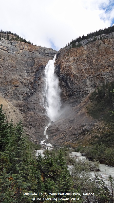
It literally thundered
as it exploded over the ledge and then dispersed down the rocky cliffs.
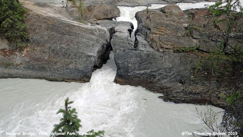
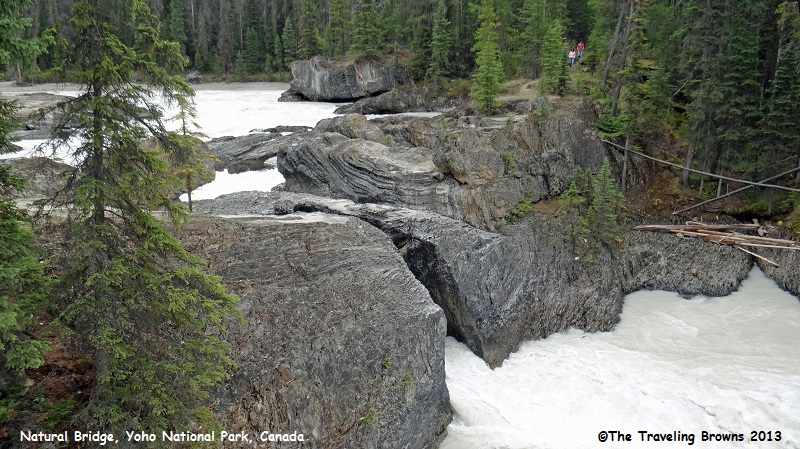
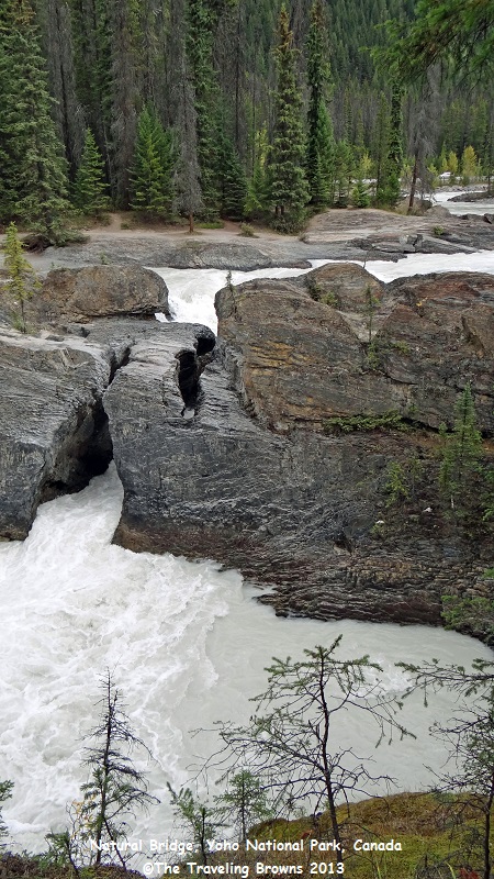
Our next stop
was Natural Bridge on the Kicking Horse River. The river was
named in 1858, when James Hector,
a member of the Palliser Expedition, was kicked by his packhorse while
exploring. Hector survived and named the river and the associated pass as a result of
the incident.
Natural Bridge is a rock formation that spans the Kicking Horse River and was sculpted by the erosive forces of the water. The main processes involved are the solution of the limestone in the river water and abrasion by sand and gravel being carried by the water. Both these processes were involved in the formation of the bridge.
At one time this bridge was a waterfall. Over time the water found its way through cracks in the rock. Softer rock found below the Natural Bridge's hard limestone band eroded more quickly, and fissures in the rock widened until the flow of water was diverted below.
Over time the passage will deepen, and eventually the bridge will collapse, creating a gorge. There was a sign at Natural Bridge that summed it up quite nicely.
“Water flows through time and wears down mountains. In the moment of our lifetime we see but a part of the process. Yesterday’s waterfall is today’s bridge, becoming tomorrow’s chasm.”
This is a shot of the Kicking Horse River approaching the Natural Bridge which is in the foreground.
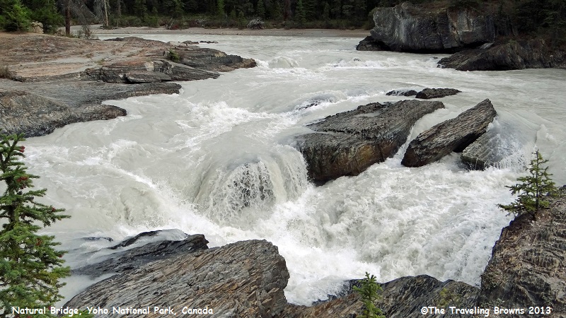
Trust us when
we say this is not a place to go tubing!
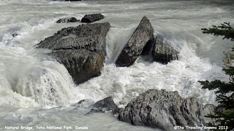
The water was boiling
out of the rock. Can only imagine what it was doing within. We walked out to
the middle of the bridge. But, when we got to the point where you had to jump
across a crack in the rock and then scale up a ledge, we said that was too much
for us! It just didn’t seem safe on our old legs.
This young
couple was coming back after hiking across the bridge.
It truly is a
spectacular area--one of Mother Nature’s many wonders.
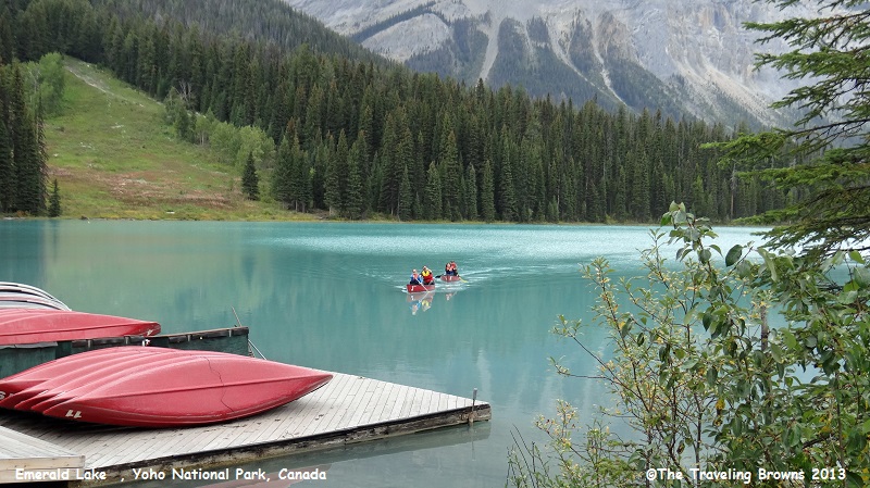
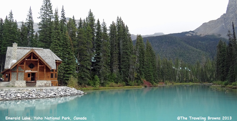
Our last
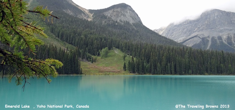
destination of the day was Emerald Lake. It is the largest of Yoho's 61 lakes and ponds, as well as
one of the park's premier tourist attractions. The
lake is enclosed by mountains of the President Range,
as well as Mount Burgess and Wapta Mountain.
This basin traps storms, causing frequent rain in summer and heavy snowfalls in
winter.
Due to its high altitude, the lake is frozen from November until June. The vivid turquoise color of the water, caused by powdered limestone, is most spectacular in July as the snow melts from the surrounding mountains.
Due to its high altitude, the lake is frozen from November until June. The vivid turquoise color of the water, caused by powdered limestone, is most spectacular in July as the snow melts from the surrounding mountains.
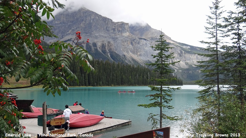
There were
folks coming and going by canoe.
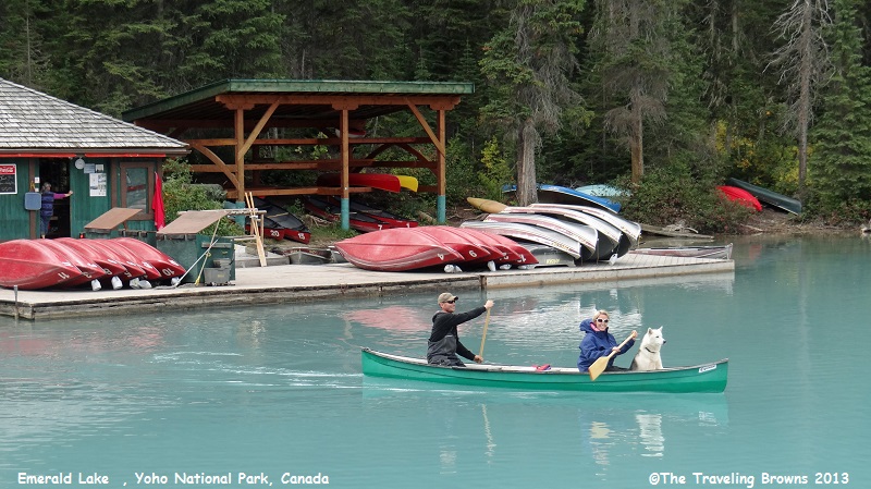
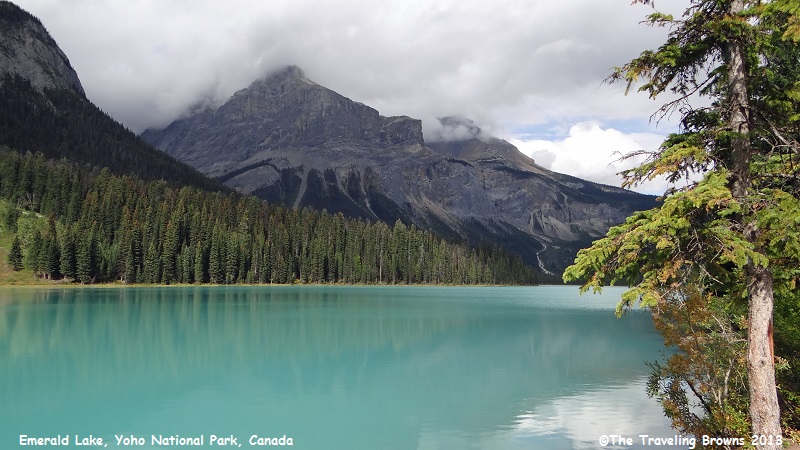
It is such a
lovely lake.
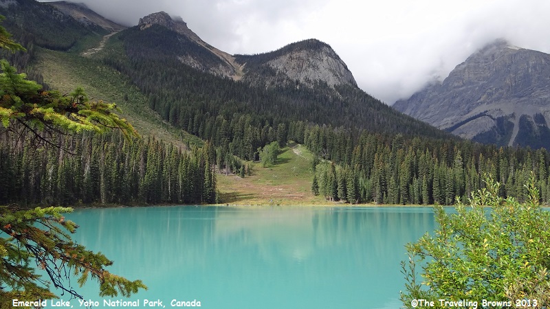
We thought the
emerald green color was pretty spectacular for mid-September. Can only imagine
how awesome it would be on a clear blue sky day.
When it started
to rain we decided to walk across a bridge to this lodge and grab a bite to
eat. However, when we arrived it had closed for the day. So, we hung out under
the eve of the roof till the rain stopped and then we called it a day.
Without a doubt Yoho National
Park offers many scenic and unique sites. We highly recommended it as a place
to visit. In our little blurb we have just scratched the surface of what it has
to offer.
Our next adventures will take us into Jasper National Park. It is one of our favorite parks to visit. Hope you can join us.
Until next time,
Dave & Barb
The Traveling Browns
Our next adventures will take us into Jasper National Park. It is one of our favorite parks to visit. Hope you can join us.
Until next time,
Dave & Barb
The Traveling Browns
