2013-16 Crater Lake National Park, Oregon
Hello All,
After staying home for the last couple of weeks in June we decided it was about time for another roadtrip. The weather in our neck of the woods was starting to get pretty hot. So, right after the 4th of July we jumped in the car and headed for Oregon. We figured the high mountains would offer some cooler temperatures. From the mountains we planned to head towards the Oregon coast. But, we don’t want to get too far ahead of ourselves so let’s get back to the mountains.
Near Bend, OR, we stopped and visited with family and friends for a couple of days. While in the area we took a drive along the Cascade Lakes Scenic Byway. The Cascade Mountain Range runs north to south down the center of Oregon and offers beautiful scenery.
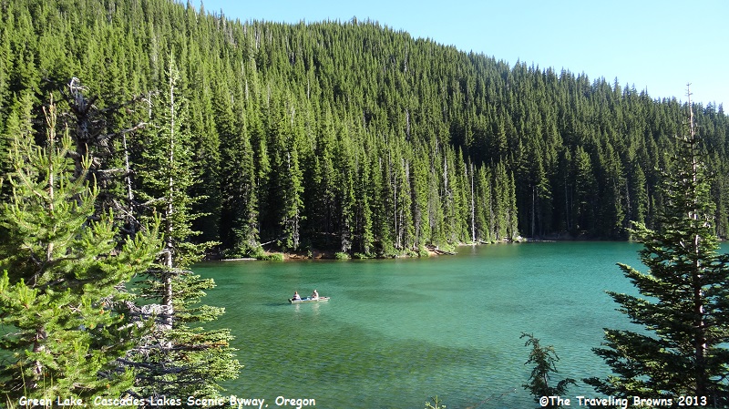
Here is a shot of a little mountain lake appropriately named Green Lake. We found the aqua green water to be quite lovely. There was a couple fishing from a small boat.
After staying home for the last couple of weeks in June we decided it was about time for another roadtrip. The weather in our neck of the woods was starting to get pretty hot. So, right after the 4th of July we jumped in the car and headed for Oregon. We figured the high mountains would offer some cooler temperatures. From the mountains we planned to head towards the Oregon coast. But, we don’t want to get too far ahead of ourselves so let’s get back to the mountains.
Near Bend, OR, we stopped and visited with family and friends for a couple of days. While in the area we took a drive along the Cascade Lakes Scenic Byway. The Cascade Mountain Range runs north to south down the center of Oregon and offers beautiful scenery.
Here is a shot of a little mountain lake appropriately named Green Lake. We found the aqua green water to be quite lovely. There was a couple fishing from a small boat.
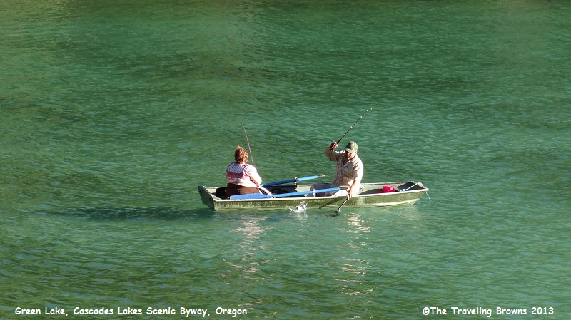
It looked like they were
having some fishing success as the man was netting a fish in this photo.
This photo is taken from
Little Lava Lake. On the left in the background is South Sister Mountain and on
the right is Broken Top Mountain. The South Sister is one of three mountains in
the area that were named Faith, Hope, and Charity by early settlers. But these
names have not prevailed, and instead they were replaced with North Sister,
Middle Sister, and South Sister. Miss Barb and family climbed the 10,053 foot
Middle Sister when she was younger.
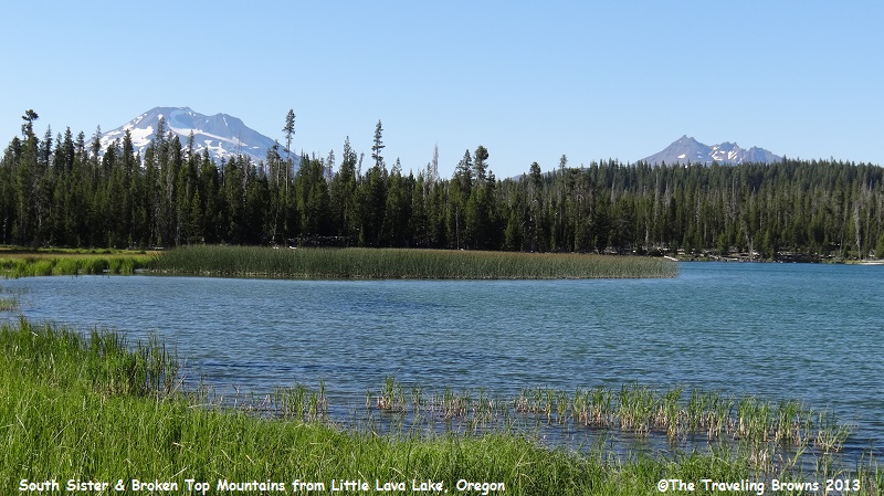
Of the three sisters the South
Sister is the tallest standing at 10,358 feet.
It is a stratovolcano that last erupted about 2,000 years ago.
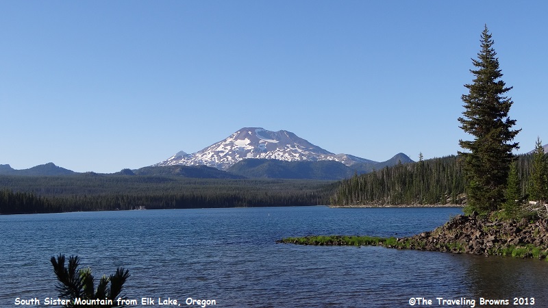
A new imaging technology known as Satellite Radar Interferometer (InSAR) is being used to measure a small uplift bulge on the South Sister. This allows the U.S. Geological Survey to continuously monitor the bulge for future changes. Its expansion is caused by rising magma 3 miles beneath the surface. To date, the bulge has only expanded 6-9 inches at the 100-square mile center.
Here is another shot of the South Sister taken from Elk Lake.
Next we drove further south in
the Cascade Mountains to a world renown destination—Crater Lake National Park.
There is no other place quite like it in the world. No place else on earth
combines a deep, pure lake, so blue in color, sheer surrounding cliffs that are
almost two thousand feet high, two picturesque islands, and a violent volcanic
past. We never pass it by when we are in southern Oregon during the summer
months.
Crater Lake has long attracted the wonder and admiration of people from all over the world. Its depth of 1,943 feet (592 meters) makes it the deepest lake in the United States, and one of the deepest in the world.
Its fresh water is some of the clearest found anywhere on earth. There are no streams running in or out of the lake. The lake water level is controlled by precipitation, evaporation, and seepage through the rocks.
Crater Lake was formed when 400,000 year old Mount Mazama had a cataclysmic eruption about 7,700 years ago. Geologists tell us the eruption lasted only a couple of days.
Eruption of the volcano was in two phases. The first produced a towering column of pumice and ash that settled over much of the western US and southwestern Canada (an area of 656,000 square miles). Then a second phase known as the ring-vent phase started the collapse of the mountain into the center. During this phase pyroclastic flows occurred (mixture of rock fragments, gas, and ash at 1470 degrees F).
Crater Lake Caldera is 5 to 6 miles in diameter and 3,900 feet deep. Since the eruption, material has fallen into the caldera from the walls and from new volcanic activity within. Scientific study of the volcano began as early as 1887.
Enough of the scientific stuff! If you have never had the opportunity to visit this one of a kind marvel put it high on your bucket list. You won’t be disappointed.
Most visitors come during the months of July through mid-September when the weather is generally mild with little precipitation. Due to the elevation of the park (6,500 feet at Park Headquarters and 7,100 feet at Rim Village) weather conditions may change quickly. On one occasion we visited the park the third week in June and found the road around the north rim had just opened the day before. Snow drifts were 15 to 20 feet deep.
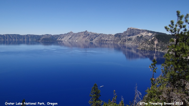
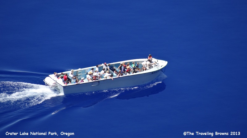
While the following photo is not a creative masterpiece we included it because it shows a boat on the lake. If you look close to the right of the tree sticking up in the lower middle, you can see a park service tour boat. It looks like a little white dash in the photo. Tour boats are quite large and hold approximately 25 passengers.
Crater Lake has long attracted the wonder and admiration of people from all over the world. Its depth of 1,943 feet (592 meters) makes it the deepest lake in the United States, and one of the deepest in the world.
Its fresh water is some of the clearest found anywhere on earth. There are no streams running in or out of the lake. The lake water level is controlled by precipitation, evaporation, and seepage through the rocks.
Crater Lake was formed when 400,000 year old Mount Mazama had a cataclysmic eruption about 7,700 years ago. Geologists tell us the eruption lasted only a couple of days.
Eruption of the volcano was in two phases. The first produced a towering column of pumice and ash that settled over much of the western US and southwestern Canada (an area of 656,000 square miles). Then a second phase known as the ring-vent phase started the collapse of the mountain into the center. During this phase pyroclastic flows occurred (mixture of rock fragments, gas, and ash at 1470 degrees F).
Crater Lake Caldera is 5 to 6 miles in diameter and 3,900 feet deep. Since the eruption, material has fallen into the caldera from the walls and from new volcanic activity within. Scientific study of the volcano began as early as 1887.
Enough of the scientific stuff! If you have never had the opportunity to visit this one of a kind marvel put it high on your bucket list. You won’t be disappointed.
Most visitors come during the months of July through mid-September when the weather is generally mild with little precipitation. Due to the elevation of the park (6,500 feet at Park Headquarters and 7,100 feet at Rim Village) weather conditions may change quickly. On one occasion we visited the park the third week in June and found the road around the north rim had just opened the day before. Snow drifts were 15 to 20 feet deep.
While the following photo is not a creative masterpiece we included it because it shows a boat on the lake. If you look close to the right of the tree sticking up in the lower middle, you can see a park service tour boat. It looks like a little white dash in the photo. Tour boats are quite large and hold approximately 25 passengers.
Taking a tour of the lake by
boat would be a wonderful experience. However, it requires hiking 2.2 miles
round trip on a strenuous trail down to the surface of the lake, and then back up
to the top of the crater rim!
Water in the lake is so blue
you would think the photos have been “photo shopped.” You have to see it in
person to comprehend just how brilliant the blue water is. Awesome and
beautiful are two adjectives that just don’t adequately describe this scenic
wonder.
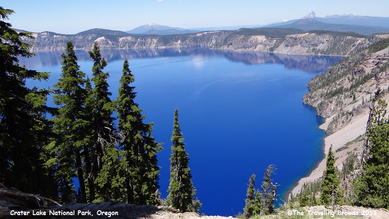
Above the lake’s surface the
rim rises anywhere from 500 to almost 2,000 feet, creating spectacular visual
effects. Encircling the rim is the scenic, 30-mile paved two-lane “Rim Drive”
road that is open during the summer season. The entire loop is below
timberline, but remains above 6,500 feet in elevation. Rim Drive is awesome and
has been named among the ten most beautiful roads in the nation by the American
Automobile Association.
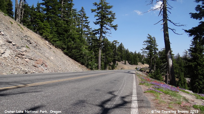
Wildflowers were in bloom along the edge of the road as we made our way along this beautiful drive.
Wildflowers were in bloom along the edge of the road as we made our way along this beautiful drive.
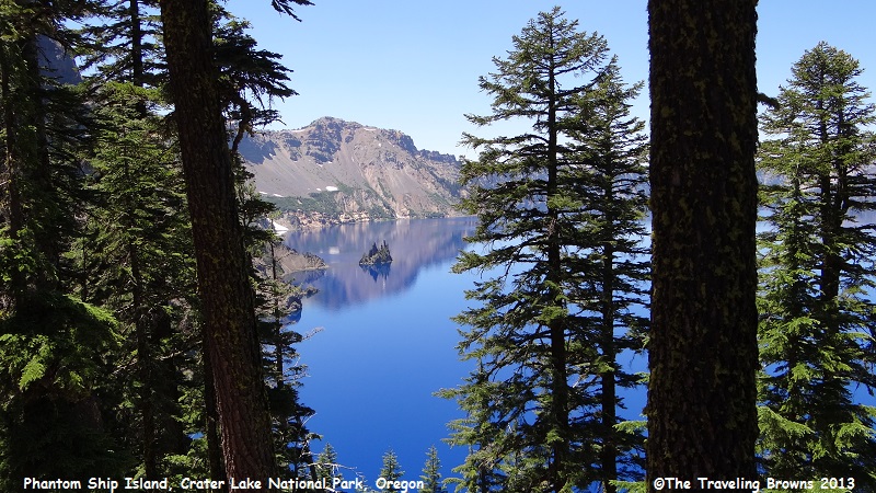
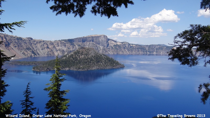
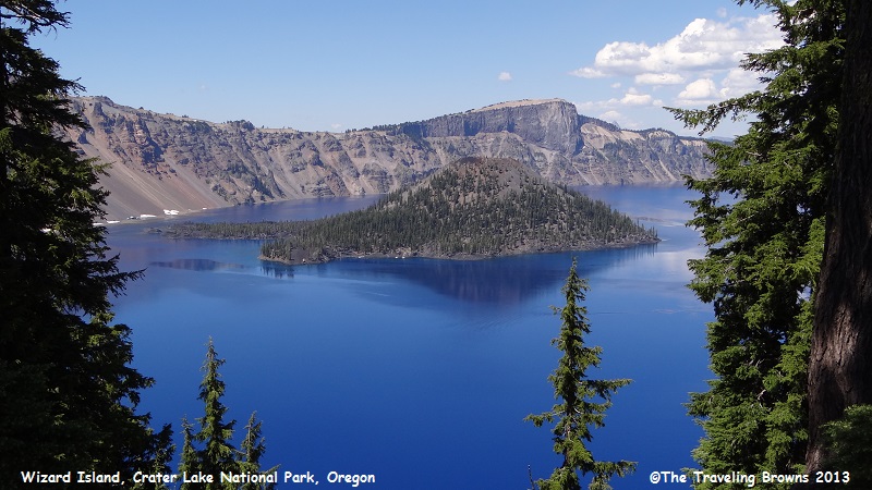
There are two islands in Crater Lake. Wizard
Island was formed from a cinder cone that erupted after the lake began to fill
with water, and there is the smaller Phantom Ship Island. Here is a shot of
Phantom Ship through the trees. It is hard to believe that seven different
species of trees live on this small island.
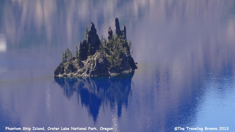
There are also colonies of
violet green swallows on Phantom Ship Island. Here’s a closer photo of the
island.
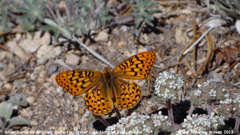
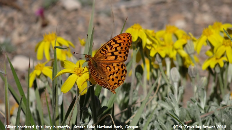
We stopped often along the Rim
Drive just to take it all in. Each stop offers a different vantage point. At
one observation point we found numerous orange butterflies fluttering around
the wildflowers. They are silver bordered fritillary butterflies.
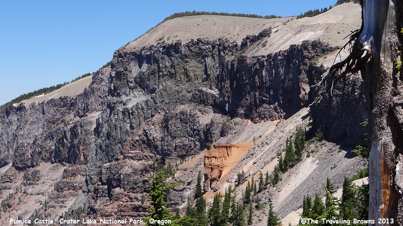
In this photo you can see a
geographical feature known as “Pumice Castle.” It is the salmon colored rock
outcropping just above the tree tops about two thirds of the way up the rim in
the following photo. Mount Mazama, the great volcano that proceeded Crater
Lake, was built up by successive eruptions of lava over may thousands of years.
Some lava oozed or poured from the volcano’s top or sides. Some erupted as
red-hot rocks that flooded down the slopes. Others exploded in the air and fell
as cinders or globs.
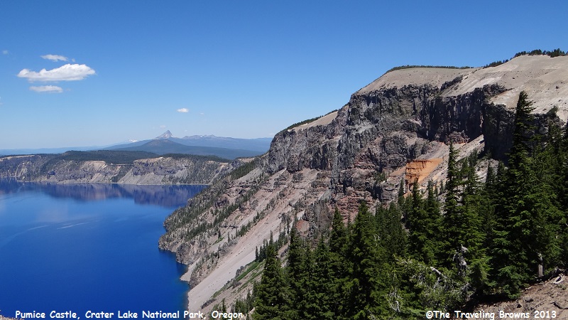
Pumice Castle is made of
layers of pumice and other rocks coughed up by Mount Mazama—some so hot they
welded together. These air fall deposits were buried and compacted by other
lavas, then exposed when Mount Mazama collapsed. A firm foundation of andesite
lava has kept Pumice Castle intact, while surrounding pumice deposits have
eroded away.
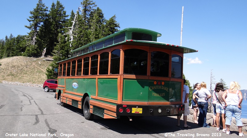
For those folks that don’t
want to make the Rim Drive there is the option of taking the Crater Lake
Trolley.
Here are a couple of shots of
the cinder cone that resulted in Wizard Island. Framed with evergreens, in our
eyes it makes for lovely photos.
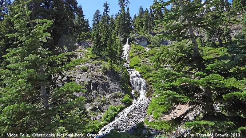
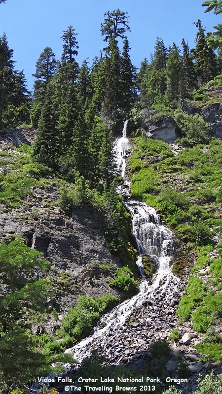
Vidae Falls is probably the
most popular waterfall within Crater Lake National Park. It is a spring-fed
cascade that drops 100 feet over a series of ledges.
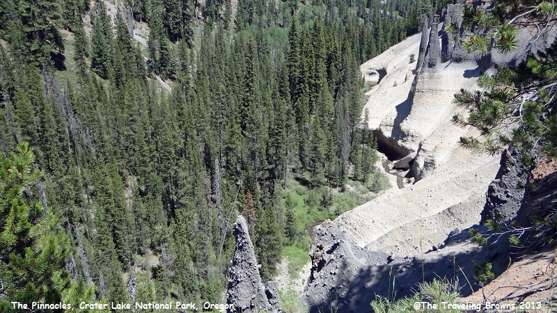
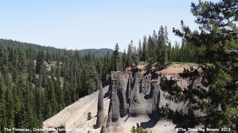
Another prominent geological
feature of Crater Lake National Park is “The Pinnacles.” These towering
needle-like formations of rock, called fossil fumaroles, projecting from the
Sand Creek Canyon floor, were formed under sheets of volcanic pumice that
preceded the collapse of Mount Mazama.
As the surface of the hot pumice cooled over the years, steam and gases were released by the hot rocks underneath through vents and tubes that were welded into cement hardness by their passage. These ancient vents now stand along the canyon wall due to the erosion of the surrounding softer materials.
We drove into Sand Creek Canyon and snapped a few photos of the pinnacles. They stretched for miles along the side of the canyon. An interesting side note is that many of the pinnacles are hollow.
Crater Lake is always
interesting and it seems we learn something new with each visit. For example,
have you heard of the “Old Man of the Lake?” The Old Man is a mountain hemlock
log that has been floating upright in the lake for more than 100 years! Wind
currents enable the Old Man to travel to different locations around the lake.
We will continue with our Oregon adventures in our next little blurb. It’s been nice having you ride along with us.
Until next time,
Dave & Barb
The Traveling Browns
We will continue with our Oregon adventures in our next little blurb. It’s been nice having you ride along with us.
Until next time,
Dave & Barb
The Traveling Browns
