2014-28 Needles Overlook & Newspaper Rock, Utah
Hello All,
When we departed Moab, Utah, the previous day to explore the Island in the Sky District of Canyonlands National Park we drove north out of town on US-191 to reach the cut-off that would take us to that district of the park. Today we wanted to explore the Needles District of the park. This required us to drive 40 miles south of Moab on US-191 and then take UT-211 roughly 35 miles west to reach this section of the park. UT-211 ends in the Needles and is the only paved road leading in and out of the district. This district of the park offers more of a backcountry experience. If you want gift shops, snack bars, or restaurants, you are not going to find them here.
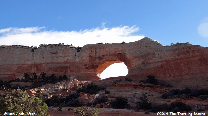
Along our 75-mile trip to the Needles District one of the first things we came across was Wilson Arch about 24 miles south of Moab. It is not in the national park, but well worth a short stop to check it out. It was named after a local pioneer (Joe Wilson) who had a cabin nearby.
The formation is made up of entrada sandstone. Over time superficial cracks, joints, and folds of the sandstone layers became saturated with water. Ice formed in these fissures during winter months and expanded the cracks. During the extreme desert heat of summer the ice melted and wind cleaned out the loose particles. Eventually, the cementing material gave way and chunks of rock tumbled out, thereby creating the arch. Wind and the elements over time have smoothed the surface of the rock.
Although not the greatest photo, we kind of liked the way the early morning sun was shining through the arch.
When we departed Moab, Utah, the previous day to explore the Island in the Sky District of Canyonlands National Park we drove north out of town on US-191 to reach the cut-off that would take us to that district of the park. Today we wanted to explore the Needles District of the park. This required us to drive 40 miles south of Moab on US-191 and then take UT-211 roughly 35 miles west to reach this section of the park. UT-211 ends in the Needles and is the only paved road leading in and out of the district. This district of the park offers more of a backcountry experience. If you want gift shops, snack bars, or restaurants, you are not going to find them here.
Along our 75-mile trip to the Needles District one of the first things we came across was Wilson Arch about 24 miles south of Moab. It is not in the national park, but well worth a short stop to check it out. It was named after a local pioneer (Joe Wilson) who had a cabin nearby.
The formation is made up of entrada sandstone. Over time superficial cracks, joints, and folds of the sandstone layers became saturated with water. Ice formed in these fissures during winter months and expanded the cracks. During the extreme desert heat of summer the ice melted and wind cleaned out the loose particles. Eventually, the cementing material gave way and chunks of rock tumbled out, thereby creating the arch. Wind and the elements over time have smoothed the surface of the rock.
Although not the greatest photo, we kind of liked the way the early morning sun was shining through the arch.
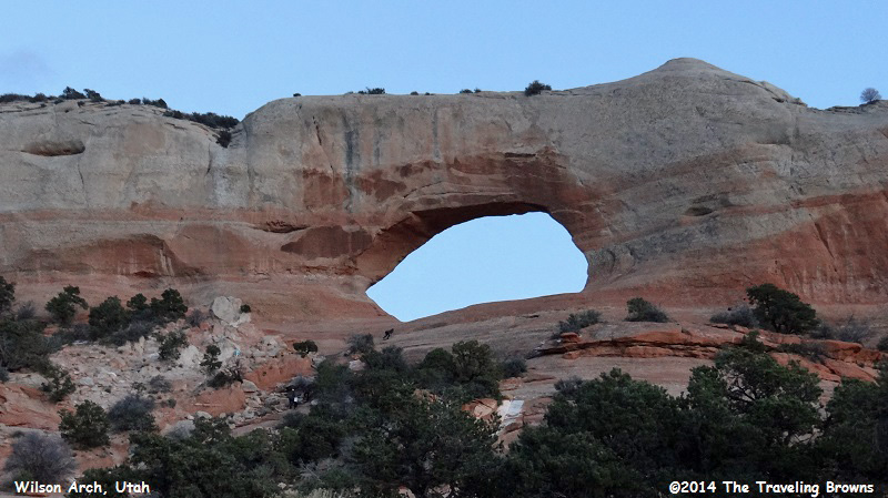
A little later we were able to capture a better photo of Wilson Arch. It is nice in that it is close to the highway and only a short walk up into it.
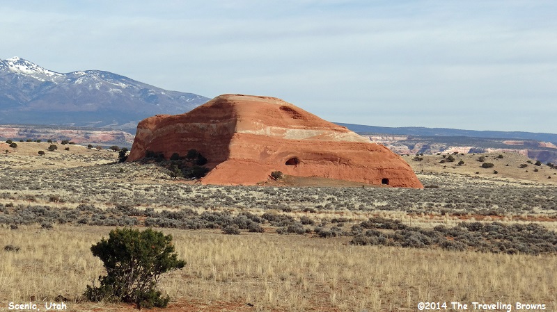
Back in the car we continued our trek towards the Needles District of Canyonlands National Park. Eight miles further down the highway we passed a road sign that was labeled “Needles Overlook Road.” Since it was our first time in the area we decided to check it out. Needles Overlook Road is also known as San Juan County Road 133.
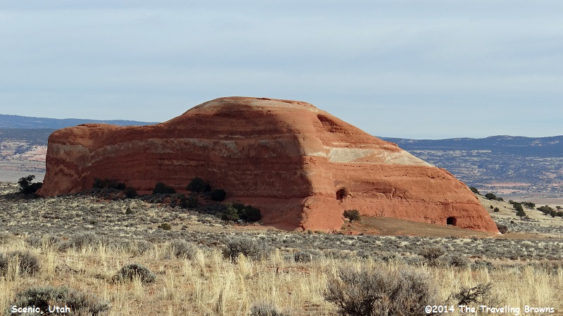
On the mostly gravel road we passed this large rock and thought it was kind of neat. It reminded us of Utah’s version of Uluru or Ayers Rock in Australia.
On the mostly gravel road we passed this large rock and thought it was kind of neat. It reminded us of Utah’s version of Uluru or Ayers Rock in Australia.
We followed the road for 22 miles where it ended at a parking area for the overlook. The Needles Overlook is not part of the national park. It is part of the Canyon Rims Special Recreation Management Area, which is managed by the Bureau of Land Management (BLM). With all that said we found it to be a fantastic place to visit for some amazing views of extremely rugged country. If you have time while in the area it is a destination we recommend checking out.
From the parking lot we walked the trail to the overlook. It was a little nippy the third week in November and there were traces of snow in the shadows.
From the parking lot we walked the trail to the overlook. It was a little nippy the third week in November and there were traces of snow in the shadows.
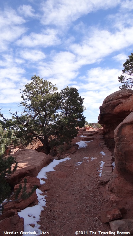
Twisted juniper trees added to the ambiance of the area.
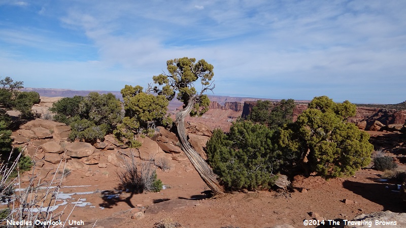
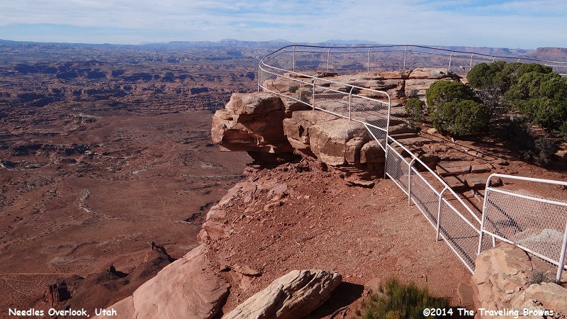
As we approached the rim of the canyon we could see it was going to provide for spectacular views.
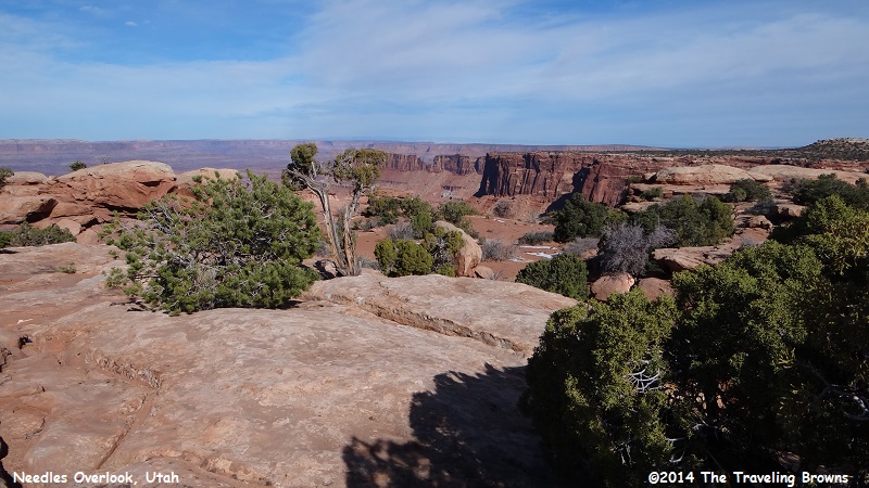
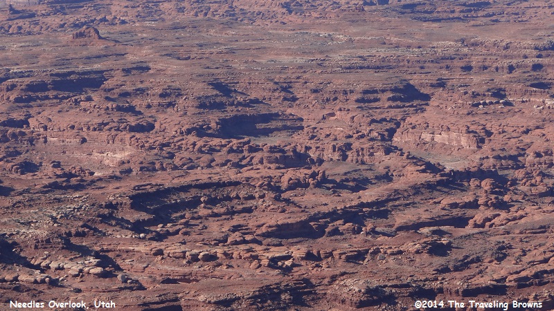
And we were not disappointed! The view of this mind-boggling terrain was amazing.
To help demonstrate just how high we were above the canyon floor we included this photo. It is not a place you would want to let pets or small children run freely.
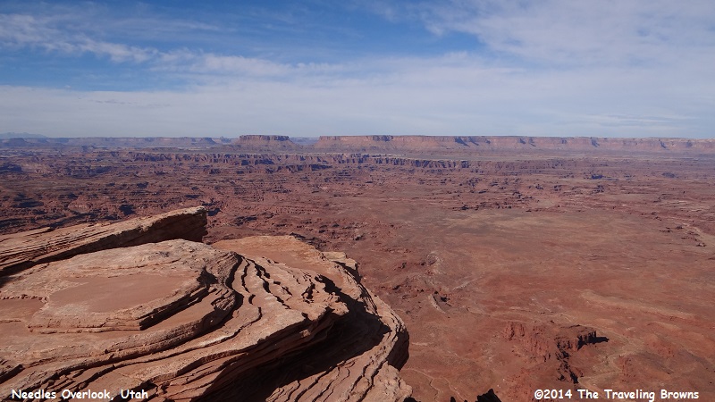
The maze below is known as The Needles District of Canyonlands National Park and is composed of cedar mesa sandstone. This layer was deposited about 225 million years ago as a coastal sand dune. Below the cedar mesa sandstone a paradox salt formation lies. In subsequent eons, the underlying salt blocks collapsed, fracturing the landscape.
We have been informed that the overlook is a wonderful place to take sunset photos, as you are looking towards the west. It is also a good place to take lightning photos of distant thunderstorms. However, safety might be a concern when these spectacular storms are close by!
We have been informed that the overlook is a wonderful place to take sunset photos, as you are looking towards the west. It is also a good place to take lightning photos of distant thunderstorms. However, safety might be a concern when these spectacular storms are close by!
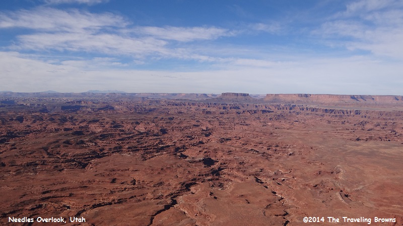
Weathering along these fractures has produced the intricate spires and needles for which the area is famous. Somewhere out there the Colorado and Green Rivers are flowing. Many of the canyons and gulches are hundreds of feet deep.
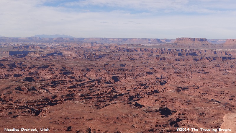
Erosive action of many forms has carved and sculpted the land. Water flowing down the canyons turns a bend and cuts deep into the opposite bank. The soil and rock which is dislodged mixes with the water, creating a tremendous eroding force, the result of which is what you see in these photos. It is not a place you should venture into without the proper research, equipment, and preparation.
Freezing water acts like a wedge in breaking down rocks. Moisture enters cracks in the rocks where it freezes, exerting great pressures, which open the cracks wider. During the day the ice melts, seeps in deeper, and when nighttime again brings freezing temperatures the process is repeated. Through this wedge-like action chunks of rock are split off. Then the power of the raindrop takes over. Exploding like a bomb, a falling raindrop blasts loose soil particles when it strikes bare ground. Flowing surface water then picks up these loose particles and carries them away. Rain falling on this barren country quickly runs off the slope and accumulates in the canyon bottoms. As a result of this rapid runoff, large volumes of water come rushing down the canyons, engulfing everything in its path. These flash floods continue to form this marvel of Mother Nature.
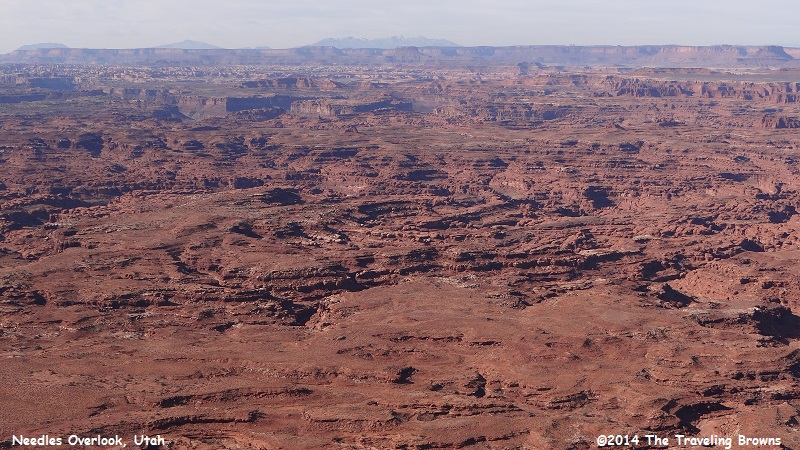
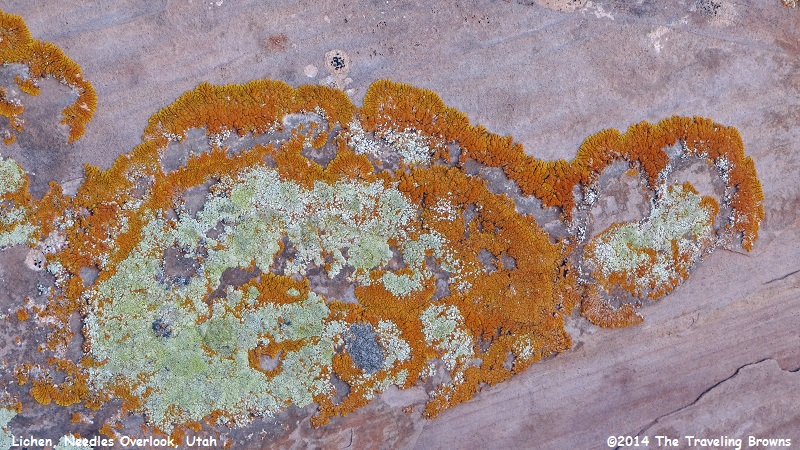
This is just a glimpse of what the Needles District of Canyonlands National Park looks like from above. Later we will be driving down into this awesome maze. But, before we leave the overlook we should mention the brilliant colors and patterns of lichen we found on the sandstone rocks. These displays were very interesting.
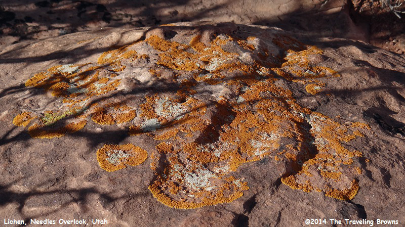
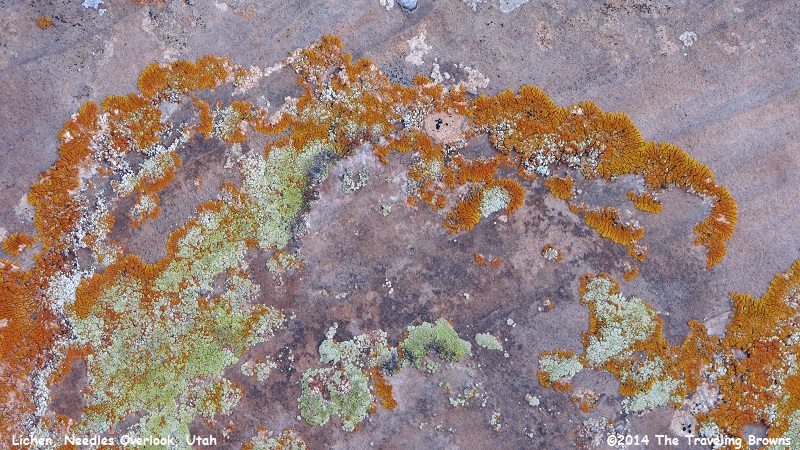
We find it amazing the many ways Mother Nature displays her artistic abstract creations.
Leaving the overlook we backtracked to US-194 and turned south till we came to UT-211 where we turned west. UT-211 is the access road into the Needles District of Canyonlands National Park. Twelve miles down the road we came to Newspaper Rock State Historic Monument. We had to stop and check it out.
Newspaper Rock is a petroglyph panel etched in sandstone that records approximately 2,000 years of early human activity. Pre-historic peoples, probably from the Archaic, Basketmaker, Fremont, and Pueblo cultures, etched on the rock from B.C. time to A.D. 1300. In historic times, Ute and Navajo people, as well as European Americans made their own contributions as well.
Newspaper Rock is a petroglyph panel etched in sandstone that records approximately 2,000 years of early human activity. Pre-historic peoples, probably from the Archaic, Basketmaker, Fremont, and Pueblo cultures, etched on the rock from B.C. time to A.D. 1300. In historic times, Ute and Navajo people, as well as European Americans made their own contributions as well.
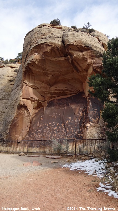
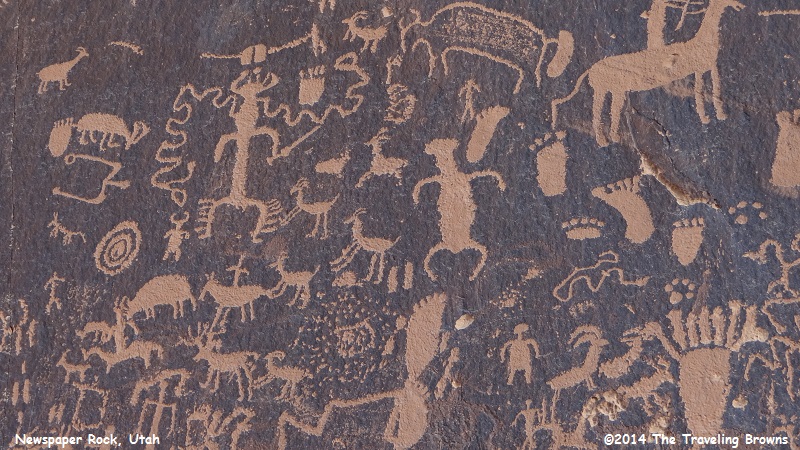
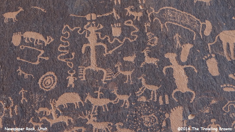
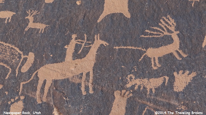
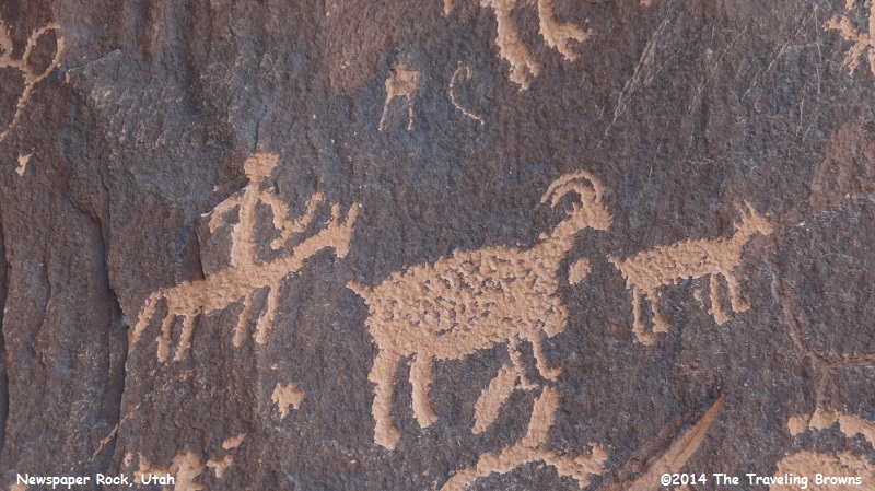
Newspaper Rock features a 200-square foot rock panel carved with one of the best preserved and largest known collections of petroglyphs in the Southwest. They feature a mixture of human, animal, material, and abstract forms.
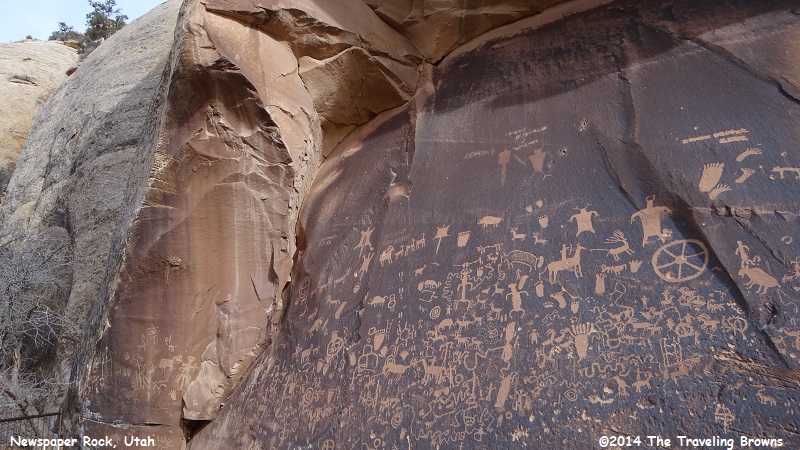
In interpreting the figures on the rock, scholars are undecided as to their meaning or have yet to decipher them. In Navajo, the rock is called “Tse’ Hane’ ” (Rock that tells a story).
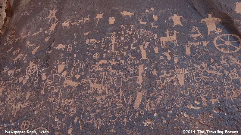
Unfortunately, it is not know if the figures represent storytelling, doodling, hunting magic, clan symbols, ancient graffiti, or something else. Without a true understanding of the petroglyphs, much is left for individual interpretation.
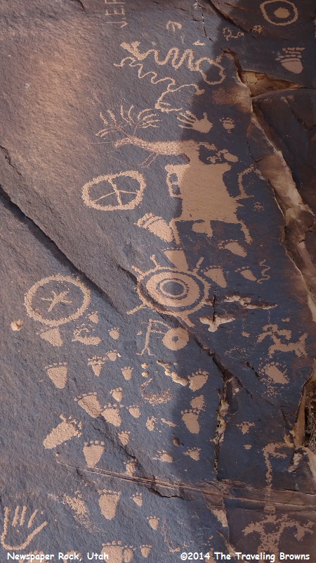
Newspaper Rock was designated a State Historical Monument in 1961, and was added to the National Register of Historic Places in 1976.
Having thoroughly enjoyed our stop at Newspaper Rock we continued our adventure towards the entrance into the Needles District of Canyonlands National Park, located another 30 miles further down the road. Hope you will consider riding along with us on that portion of our roadtrip.
Until next time,
Dave & Barb
The Traveling Browns
Until next time,
Dave & Barb
The Traveling Browns
